PELOPONNESE

Popular destinations GREECE
| Aegina | Alonissos | Andros |
| Chios | Corfu | Crete |
| Hydra | Kalymnos | Karpathos |
| Kefalonia | Kos | Lefkas |
| Lesbos | Mykonos | Naxos |
| Paros | Patmos | Peloponnese |
| Poros | Rhodes | Samos |
| Santorini | Skiathos | Skopelos |
| Spetses | Thasos | Zakynthos |
Geography and Landscape
Geography
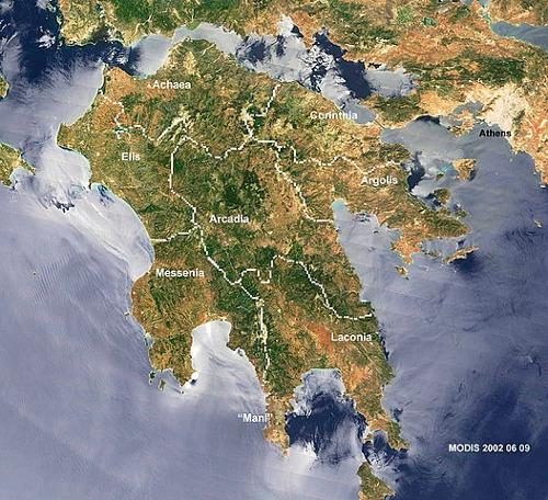
The Peloponnese (also called Morea after the shape of the leaf of the mulberry tree) is the largest peninsula in Greece, located south of the Greek mainland and southwest of the capital Athens.
The Peloponnese is separated from the Greek mainland by the Gulf of Corinth, part of the Ionian Sea, and the Gulf of Aegina (also known as the Saronic Gulf), part of the Aegean Sea, and connected to it by the isthmus of Corinth (about 10 km wide). This isthmus is crossed by the Corinthian Canal (almost 6.5 km long, 23 m wide and 8 m deep), which could be said to have artificially transformed the Peloponnese from a peninsula into an island.
The surface area of the Peloponnese is about 21,400 km². Cape Matapan (also called Tainaro) is the southernmost point of the Peloponnese, with cliffs up to 50 m high. The nearby cave was regarded by the ancient Greeks as the entrance to Hades, the kingdom of the dead.
The Argo-Saronic islands lie to the east of the Peloponnese, the Ionian islands to the west and south of the peninsula. Some of the islands are not far from the Peloponnese coast, such as Proti, Sapienza, Schiza, Elafonisos, Kythira, Spetses, Dokos, Hydra, Poros, Aegina and Agistri.
 Peloponnese Satellite PhotoPhoto: Public Domain
Landscape
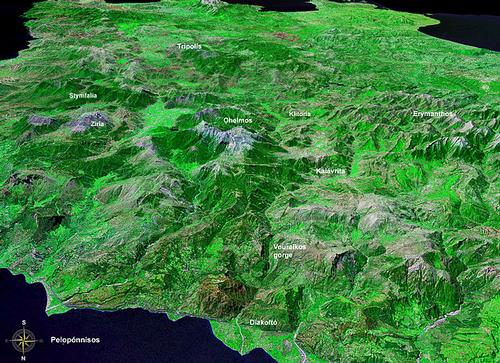
The Peloponnese has a great variety of landscapes, but the predominant ones are the mountainous areas, approximately two-thirds of the Peloponnese are mountainous. The Peloponnese also has a number of rivers, among them the Neda, the Selinountas, the Dafnon, the Pineios, the Evrotas, the Polilimnio, the Alphios, the Vouraikos, the Erymanthos, the Sireos, the Aroanios, the Krathis, the Krios and the Lousios. The largest lake in the Peloponnese is Lake Stymphalia, and near Porto Cheli, 80 km south of Nauplion, is Lake Ververontas.
The wild, scarcely inhabited region of Arcadia is central to the Peloponnese. Hikers enjoy a trip through the Lousios Gorge, about 5 km long and 300 metres deep.
North of Arcadia is Achaea, with on its border with Arcadia a mountain range with peaks of about 2300 metres. The 1926 m high Panachaiko dominates the coastal region near Patras, in the south of the Aechaea region lie the even higher Aroania (2341 m) and the Erymanthos (2224 m). Other mountain ranges are Kollis, Omplos, Kombovouni and Movri. The main rivers are from east to west the Vouraikos, the Selinountas, the Charadros, the Peiros, the Tytheus and the Larissos.
Achaea borders the Gulf of Corinth in the north, has many beautiful sandy beaches and in addition to the wetlands-nature reserves Kato Achaia and Varda also the nature reserve Kalogria. Forests, but also dry, barren areas are mainly to be found in the mountainous regions, grasslands in the somewhat lower regions. Satellite photo PeloponnesePhoto: NASA in the public domain
Southwest of Achaea is the flat region of Elis, the westernmost region of the Peloponnese. The longest river in this region is Alphios, other rivers are the Erymanthos, the Pineios and the Neda. Except for the Erymanthos, all these rivers flow into the Ionian Sea. The eastern part of Elis is forested, while in the south pine trees predominate. Near the village of Foloi and in the mountainous east there are some nature reserves. About a third of the land, especially in the north, is fertile and suitable for agricultural activities, the rest is mountainous. Elis has a number of mountain ranges, including Movri (max. 400 m high), Divri (max. 1500 m) and Minthe (max. 1100 m). About 1-1.5% of the area used to be marshland, particularly in the Samiko area; only about 10 km2 of this area is protected marshland, the rest has been made suitable for agriculture. Elis lies in a seismically active zone, with earthquakes in 1909, 1910, 1920, 1953 and 2008. In August 2007, Elis was hit by massive forest fires, destroying 8,500 ha of forest and 2,300 ha of agricultural land.
In the south-eastern corner of the Peloponnese lies Laconia, a large fertile plain surrounded by the high peaks of the Taigetos mountain range (100 km long; highest peak and third highest mountain in Greece, Profitis Ilias, 2407 m and named after the prophet Elijah) and more hilly Parnon mountains (90 km long; highest peak is Malevos, 1935 m), and bisected by the Evrotas river, which flows into Laconia Bay for about 100 km. The valley through which the Evrotas flows is fertile and yields the largest harvest of oranges in all of Greece.
Remarkable is the rock of Monemvassia, located on Vatika, the most eastern peninsula of the Peloponnese. This rock was once part of the Peloponnese, but in 375 AD an earthquake turned it into a rocky island. Of particular interest is the Kastania cave near Neapoli, where 3 million-year-old stalagmites and stalactites can be seen. This region has countless springs; the Anakolou Gorge above Xirokambi alone, where the oldest stone arch bridge in Europe is still passable, has more than sixty springs. Apart from the capes of Malea and Tainaron and a part of the Mani peninsula, the island of Elafonisos also belongs to Laconia.
In the south-western corner of the Peloponnese is the region of Messenia with the river Neda, a rocky coast and very fertile plains. The Polylimnio waterfalls and the Kadoula and Kadi lakes near the villages of Kazarma and Charavgi are relatively unknown. The most important mountain ranges are those of the Taygetus in the east, Kyparissia in the northwest and Lykodimo in the southwest. The main rivers are the Neda in the north and the Pamisos in central Messinia.
Just north of the Bay of Navarino is Voidoikoilia Beach, rated by the authoritative New York Times newspaper as one of the ten most beautiful beaches in the world. Southwest of Messinia are the mostly uninhabited Oinousses Islands, the largest of which are Sapientza, Schiza and Venetiko. The small island of Sphacteria practically closes off the bay of Pylos.
Three peninsulas characterise the south of the Peloponnese. In the north of the middle peninsula, the Mani, are the mountains Helmos (2338 m) and Killini (2374 m). The landscape of the Mani is dominated by the many tower houses. The western peninsula is called Pylia and the eastern peninsula is called Vatika.
The area around Pyrgos Dirou on the Mani is literally littered with caves and cave systems (at least 70 km long), of which the Diros caves, carved out by the underground Vlychada River, are the most important. In these caves, important evidence of early human and Neanderthal habitation, among others, has been found. Although the caves, including the Glyvada Cave, the Alepotripa Cave and the Katafigi Cave, had been known to local people since 1895, it was not until 1949 that thorough research began and they were opened to the public in 1967.
In the northeast of the Peloponnese are the regions of Corinth and fertile Argolis, with much agriculture, but also popular beaches and, on the Methana peninsula, a volcano, 32 extinct craters and hot sulphuric and saline springs. Volcanic activity has not occurred there for over 300 years.
The highest point in Corinth is the 575-metre-high Akrokorinth. Central Argolis has the most arable land, where mainly lemons and oranges are grown. Argolis is bordered to the northeast by the Saronic Gulf and to the south and southwest by the Argolic Gulf. Important mountain ranges are Oligyrtos in the northwest, Lyrkeio and Ktenia in the west and Arachnaio and Didymo in the east.
Sources
Wikipedia
CIA - World Factbook
BBC - Country Profiles
Last updated January 2026Copyright: Team The World of Info