NORMANDY
Geography and Landscape

Geography and Landscape
| Basic information | |
| Official language | French |
| Capital | Rouen |
| Area | 30.627 km² |
| Population | 3,307,286 (2021) |
| Currency | euro (EURO) |
| Web | .fr |
| Code. | FRA |
| Tel. | +33 |
Popular destinations FRANCE
| Alsace | Ardeche | Auvergne |
| Brittany | Burgundy | Cevennes |
| Corsica | Cote d'azur | Dordogne |
| Jura | Languedoc-roussillon | Loire valley |
| Lot | Normandy | Picardy |
| Provence |
Geography and Landscape
Geography
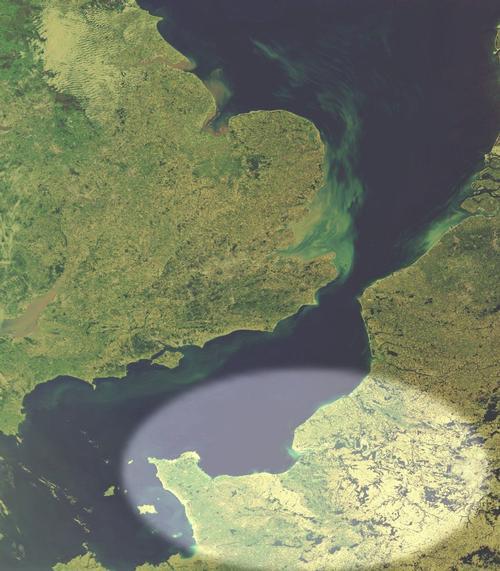
Normandy (French: La Normandie) is a region in north-western France, located along the English Channel. The total area of Normandy is 30,627 km2, which is 5% of the surface area of France. Normandy borders from east to west on the regions Picardie, Île de France, Centre, Pays de la Loire and Brittany. The total coastline is about 650 km long.
Normandy consists of the regions Haute-Normandie at the lower Seine and the more western Basse-Normandie including the peninsula Cotentin.

Haute-Normandie consists of the departments Seine-Maritime and Eure, while Basse-Normandie consists of the departments Orne, Calvados and Manche.
At 17 km by boat from Granville is the archipelago Îles Chausey, with about 50 islands and more than a hundred granite reefs. The largest island of the archipelago is La Grande Île (2 km long and up to 700 m wide).
West of the Cherbourg peninsula and south of the main shipping lanes in the English Channel, the Channel Islands of Alderney, Guernsey, Herm, Jersey and Sark lie in the middle of the warm Gulf Stream.
This archipelago also includes the small islands of Brecqhou and Jethou and the rocky islets of Minquiers, Écrehous, Dirouilles, Paternosters and Casquets.
Landscape
Normandy consists of five departments, each with its own landscape characteristics. The interior can be divided into the 'campagne' and the 'bocage'. The campagne is an open landscape with dry plains and many fields. The bocage is a man-made coulisse landscape, characterised by a network of earthen walls topped by dense hedges that surround fields and meadows. The region south of Caen and Saint-Lô is called "bocage normand".
Seine-Maritime is the northernmost department and consists of Pays de Bray in the east and Pays de Caux on the coast. Pays de Bray is an area with extensive forests and many orchards and pastures. The area is only 70 km long and barely 20 km wide and the geological structure consists of a lot of limestone with many springs and alternating sandy and clay soils.
Pays de Caux is a vast limestone plateau (between 120 and 250 metres high) that is bordered on the coast by very steep chalk cliffs with alternating layers of flint and yellow marl: a so-called falaise coast. The plateau is lightly covered with fertile silt deposits and there are meadows, orchards, woods and fields. On the rocks, the so-called hanging or floating valleys, the 'valleuses', emerge. In fact, these are dry river valleys. Due to the ever-retreating coastline, they now end up in the air instead of in the sea and therefore appear to be floating. The impact of the sea is causing the cliffs to lose about 3 million m3 of chalk.
The coastline here is called the Côte d'Albâtre (Alabaster Coast), and runs from Le Tréport in the north to Le Havre in the south. France's most famous river, the Seine, flows into the English Channel in the Seine-Maritime region. Pieces of flint from rocks polished by the sea are characteristic of the Côte d'Albâtre. These stones are among the hardest in the world.
Eure is a green, hilly and woody area around the Seine with rolling meadows and apple orchards.
Manche, with the Cotentin peninsula, has 330 kilometres of coastline and is either rocky (north coast) or has extensive sandy beaches (east and west coast). The infertile, humus-poor soil is only suitable for (saline) pastures.
The Pays d'Auge, a region that symbolises the whole of Normandy, is the beautiful hinterland of the Côte Fleurie, the most famous and fashionable beach region of Northern France. The area is still partly covered with primeval forest. The steep, up to 30 m high limestone cliffs form the Côte d'Auge and offer a view of the Dives valley.
Suisse Normande is a beautiful part of Normandy in the Orne department, but it does not look like the real Switzerland, because there are no mountains at all. The area is situated south of Caen, between Thury-Harcourt and Argentan. It is an area with forests, rocks, hills and fast-flowing waters.
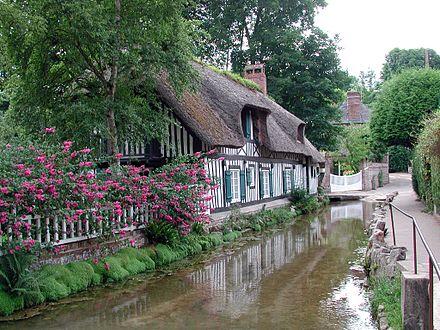
The shortest river of France is the Veules (1100 metres) which flows into the Channel.
 Veules flows through the village of Veules-des-RosesPhoto: Nikater in the public domain
Parc Naturel Régional Normandie-Maine
This park dates back to 1975 and stretches over two regions (Lower Normandy and the Pays de Loire), has an area of 235,000 ha and includes 150 municipalities in the departments of Orne, Manche, Mayenne and Sarthe.
The park is divided into an 'haut pays' (high land) with ridges and forested slopes in the Alpes Mancelles, and a 'bas pays' (low land), which is characterised by its bocage landscape, the rolling hills of the Saosnois and the open fields around Sées and Alençon.
The landscape also consists of impressive forests, such as Écouves, Andaines, Perseigne, Sillé and the Alpes Mancelles.
Parc Naturel Régional des Marais du Cotentin et du Bessin
This natural park was opened in 1991, encompasses 144 municipalities and of the Calvados and the Manche, and has an area of approximately 140,000 ha (of which 27,000 ha are marshes and polders). It stretches from the bay of Les Veys on the east coast of the Cotentin peninsula to the port of Lessay on the west coast.
The park is characterised by a partly peat and partly bocage landscape with many marshes, several canals and a rich plant and animal life with egrets, shelducks, curlews, lapwings, storks and oystercatchers, among others. The relatively high vegetation makes these treeless, marshy plains an excellent breeding ground and wintering area for migratory birds.
Parc Naturel Régional des Boucles de la Seine Normande
This nature park was opened in 1974 and is located on both sides of the Seine in the urbanised area west of Rouen.
A large part of the 40,000 ha park is Bosnia-Herzegovina, the Forêt Domaniale de Brotonne, which consists mainly of beech trees with the occasional hornbeam and oak.
Parc Naturel Régional du Perche
This nature park was created in 1998 and is located in the administrative regions of Lower Normandy and Centre. It covers an area of 182,000 ha and is characterised by gently rolling hills, bocage landscapes, deep forests of beech, oak and pine, and meadows surrounded by hedges and copses.
Sources
Graaf, G. de / Normandië, Bretagne
ANWB
Normandië
Touring/Lannoo
Normandië, Kanaaleilanden
Michelin Reisuitgaven
Normandië, west : Caen, Mont-St-Michel, Guernsey, Jersey
Lannoo
Radius, J. / Normandië, Bretagne
Gottmer/Becht
Reiser, H. / Normandië
Van Reemst
Vermoolen, S. / Normandië
ANWB
CIA - World Factbook
BBC - Country Profiles
Copyright: Team The World of Info