LA PALMA


Popular destinations SPAIN
| Andalusia | Catalonia | Costa blanca |
| Costa brava | Costa del sol | El hierro |
| Formentera | Fuerteventura | Gran canaria |
| Ibiza | La gomera | La palma |
| Lanzarote | Mallorca | Menorca |
| Tenerife |
Geography and Landscape
Geography
The Canary Islands (Spanish: Islas Canarias) are located in the Atlantic Ocean west of Africa, at the same altitude as Morocco. The archipelago consists of seven inhabited main islands and six smaller ones. The main islands are Tenerife, Fuerteventura, Gran Canaria, Lanzarote, La Palma, La Gomera and El Hierro.

The Canary Islands also include the four small islands of La Graciosa, Montaña Clara, Alegranza and Los Lobos, as well as two rocky islands, Roque del Oeste and Roque del Este.
The Canary Islands are geographically part of Africa, but politically they have been part of Spain since the 15th century. The archipelago consists of two provinces under the name: Autonomous Region of the Canary Islands.
Of the seven large islands in the Canary archipelago, La Palma (full name San Miguel de La Palma) is the smallest after La Gomera and El Hierro.
The total area of La Palma is 726 km2, which makes it slightly smaller than Lanzarote. The maximum distances on the island are 29 km from east to west and 47 km from north to south.
Landscape
Like other islands in the Canary archipelago, La Palma is an island of contrasting landscapes. Roughly speaking, La Palma has barren lava soil in the south and an exuberantly vegetated hilly landscape in the north. One of the reasons for this is the large difference in rainfall.
The south of La Palma consists of a young volcanic landscape, of which the traces of recent eruptions are still visible. This part of the island is dominated by the mountain ridges Cumbre Nueva and Cumbre Vieja.
Scattered along the latter mountain range are around 120 craters, seven of which have been active in the last 500 years. This makes the Cumbre Vieja one of the most active volcanic areas in the world.
Volcanic eruptions on the Cumbre Vieja
1470-1492 Montaña Quemada
1585 Tajuya (El Paso)
1646 Volcán Martín
1677 Volcán San Antonio
1712 El Charco
1949 Volcán San Juan, Duraznero and Hoyo Negro
1971 Volcán Teneguía
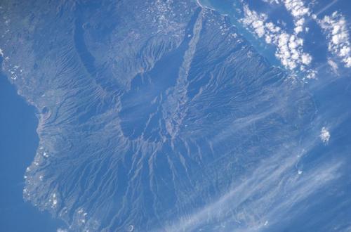
One of the largest extinct craters in the world is located on the northern part of the island and forms the national park (since 1954) Caldera de Taburiente. This gigantic crater has a diameter of ten kilometres, a circumference of 28 kilometres and a maximum depth of 1,500 metres. The slopes of the Caldera (Spanish for 'cirque') are criss-crossed by deep ravines or 'barrancos'.
Exactly how old the Caldera is (2-4 million years) and how this giant crater was formed is still not entirely clear. That it is a volcanic crater is very unlikely; nowadays it is assumed that the Caldera arose from volcanic deposits below sea level, which were then pushed up to 4000 metres above sea level millions of years ago by shifts or volcanic activity. Then either a long-term erosion process started or perhaps a hollow space was created under the centre of the Caldera and collapsed at some point.
In the interior of the crater, an abundance of water can be found throughout the year in streams, brooks and waterfalls. However, the more than one hundred springs produce less and less water per second.
In 1971, the last volcanic activity on La Palma took place, which was also the last activity on the Canary Islands. On the slope of San Antonio, another volcano arose: the 439-metre-high Volcán Teneguía. The eruption lasted 25 days in total.
During eruptions of volcanoes in the south, sometimes huge areas are covered with ashes and 'lapilli' (lumps of stone of volcanic origin). This is how the 'jables' were created, the bizarre landscape covered with a layer of dark ash somewhat reminiscent of a sandy desert. The largest and best known jable of La Palma is El Llano del Jable. Mulberry trees can still be found in this area, the leaves of which serve as food for the silkworm. Nowadays there are still a few silk weavers active.
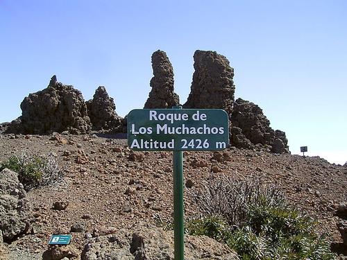
The highest point of La Palma is the impressive Roque de los Muchachos with 2426 meters, located on the edge of the Caldera de Taburiente. This makes La Palma officially the steepest island in the world in proportion to its total area.
Other high peaks are the Pico de la Nieve (2239 metres), Pico del Cedro (2247 metres), Pico de la Sabina (2134 metres), Pico del Cedro (1914 metres), Pico Corralejo (2044 metres) and Pico Ovejas (1854 metres).
La Palma even has some small rivers, such as the Angustias.
 Roque de los Muchachos, highest mountain of La PalmaPhoto: Frank Vincentz CC 3.0 Unported no changes made
Sources
Canarische eilanden
Van Reemst
Evers, K. / Canarische eilanden : Tenerife, La Gomera, El Hierro, La Palma, Gran Canaria, Fuerteventura, Lanzarote
Gottmer
Klöcker, H. / La Palma
Deltas
Lipps, S. / Wandelgids La Palma
ANWB
Murphy, P. / Canarische eilanden
Kosmos-Z&K
Renouf, N. / Canarische eilanden
Kosmos-Z&K
Rochford, N. / Wegwijzer voor La Palma en El Hierro : een landschapsgids
Sunflower Books
Schulz, H.H. / La Palma
Van Reemst
Valk, T. / Wandelgids La Palma : 16 wandelroutes
Elmar
CIA - World Factbook
BBC - Country Profiles
Copyright: Team The World of Info