LOT
Geography and Landscape

Geography and Landscape
| Basic information | |
| Official language | French |
| Capital | Cahors |
| Area | 5.217 km² |
| Population | 173,166 (202019) |
| Currency | euro (EUR) |
| Web | .fr |
| Code. | FRA |
| Tel. | +33 |
Popular destinations FRANCE
| Alsace | Ardeche | Auvergne |
| Brittany | Burgundy | Cevennes |
| Corsica | Cote d'azur | Dordogne |
| Jura | Languedoc-roussillon | Loire valley |
| Lot | Normandy | Picardy |
| Provence |
Geography and Landscape
Geography
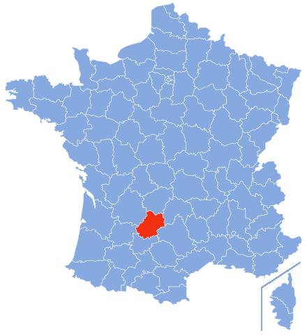
Lot (former provincial name was Quercy) is a French department located in the Midi-Pyrenees region. The department borders the departments of Corrèze, Cantal, Aveyron, Tarn-et-Garonne, Lot-et-Garonne and Dordogne. The department Lot has an area of 5217 km2.
 Location Lot in FrancePhoto:Marmelad CC 2.5 Generic no changes made
Landscape
Lot (Quercy) arose about 250 million years ago from the deposition of sediments from the sea. The limestone plateaux of Lot (a.o. Causse de Limogne, Quercy Blanc and the Causse de Gramat) are about 300 to 400 metres above sea level, except in those places where the river water has cut deep gorges in the limestone soil. Lot lies entirely in the area "Le Quercy" which is also called "La terre des merveilles".
In the east lies the Ségala, a barren mountainous area with many ravines and covered with winter and summer oaks, pines and chestnut trees. Further west is the Limargue, a narrow strip of clay and calcareous soil. The hilly fertile area is covered with a coulisse landscape. In the west of Lot is the very wooded, hilly Bouriane, a transition area between the limestone plateaus and the Périgord Noir with chestnut forests and many summer oaks. The gravelly soil is not suitable for agriculture. South-west of Cahors the causses change into 'planhès', a hilly landscape with large chalk plateaus, the Quercy Blanc.
No less than three rivers run through the Jura limestone plateaus or 'causses' of the Lot: in the south the Lot and Célé rivers, in the north the Dordogne. The Causses region consists, from south to north, of Causse de Caylus, Causse de Limogne, Causse de Cajarc, Causse de Gramat and Causse de Martel. The causses are grouped together under the name "Parc Naturel Régional ds Causses du Quercy".
The sparse vegetation here (all the rainwater disappears into the porous soil) consists mainly of grassland, truffle oaks, thorn bushes and juniper bushes. The "causses" are rich in caves, underground rivers and deep wells or "gouffres". A "gouffre" is a vertical cave with a relatively small opening at the surface that widens further down.
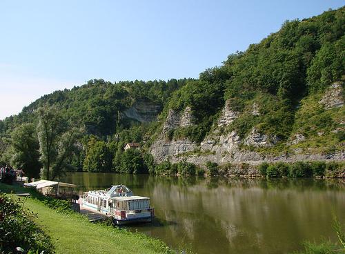
Most of the department is crossed by the 480 km long Lot, a tributary of the Garonne and Dordogne rivers. The Lot has its source on the Mont Lozère and its main tributaries are the Truyère and the Célé.
 River LotPhoto: Vassil in the public domain
Gorges and caves
Carbonated rainwater dissolves the calcium carbonate in the limestone, creating small bowl-shaped valleys or depressions called "cloups" or "dolines". When rainwater penetrates deeper into the ground through cracks in the soil, natural karst pits and gorges called "edzes" or "eidges" in Lot are formed by the erosion and dissolution of the rock.
Over time, rainwater that has seeped into the ground has carved out underground passages, after which all that water comes together in a river, fast-flowing or otherwise. These rivers sometimes contain abrasive materials, widen their beds and often plunge as waterfalls. In slow-flowing rivers, natural dams, the 'gours', form upstream as a result of calcium deposits. Sometimes a river flows so slowly that the water is calcified. This is called a petrified river.
Sometimes the limestone crust above the underground water dissolves further, after which the vault crumbles and a dome is formed. The top of this dome lies close to the ground surface and if the dome becomes too thin, it can collapse and create a huge hole, a chasm or 'gouffre'. The most beautiful example of such a gouffre can be seen at the Grand Dôme de Padirac or Gouffre de Padirac.
In some caves, dripping water creates whimsical limestone formations, such as cones, pyramids and draperies:
Stalactites: hanging from the vault of a cave, usually hollow and pointed
Stalagmites: form at the bottom of a cave, usually massive and rounded
Column: stalactite that grows up against a stalagmite
Eccentrics: very fine, laterally crystallised, needle-shaped stalactites or stalagmites (max. 20 cm)
Discus: special shape due to crystallisation
Sources
Best, J. / Dordogne, Limousin met Quercy en Berry
Gottmer/Becht
Denez, F. / Dordogne, Lot, Périgord, Quercy
ANWB
Dordogne, Périgord : Périgueux, Bergerac, Cahors, Rocamadour
Lannoo
Graaf, G. de / Dordogne, Limousin
ANWB
CIA - World Factbook
BBC - Country Profiles
Copyright: Team The World of Info