ARIZONA
History

History
Popular destinations USA
| Arizona | California | Florida |
| Hawaii | Utah |
History
History of Arizona to the arrival of the Spaniards
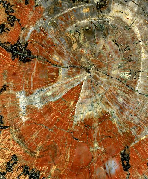 2230 million year old petrified trees in ArizonaPhoto: Michael Gäbler CC 3.0 Unported no changes made
Some 25,000 years ago, during the last Ice Age, the first humans from Asia entered North America via the Bering Strait. These early Americans were hardened nomadic hunters who attacked mammoths, cave bears, and giant sloths with simple weapons. Due to the warming of the climate the glaciers withdrew and the nomads moved further south. The oldest archaeological finds of these people in the southwest of the later United States date back to about 11,000 years ago. Because the large mammals were extinct, the nomads hunted small mammals such as deer and rabbits, and more and more berries, nuts and fruit were also collected: the hunter-gatherer was created.
From 3000 BC. Contacts with farming communities in Central Mexico led to the emergence of agriculture in Arizona. Maize was about the first product to be cultivated, from about 500 BC. beans and pumpkins were added.
Around 100 AD. Three major cultures emerged in the Southwestern United States, the Hohokam culture in the deserts, the Mogollon culture of the central mountain ranges and valleys, and the Old Pueblo peoples, previously called Anasazi, who lived on the Colorado Plateau and then particularly in the Four Corners area, where the current borders of four US states, Arizona, Colorado, New Mexico, and Utah, meet.
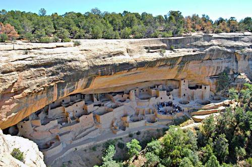 Dwellings in the rocks of the Ancient Pueblo Peoples Photo: Lorax CC 3.0 Unported no changes made
The intrepid Hohokam Indians survived in the deserts of Arizona between 300 BC. to 1400 AD. by a very advanced irrigation system created by rivers for that time. Other activities indicated a great relationship with cultures in Mexico and Guatemala.
Named after the mountainous regions of the same name in western New Mexico and eastern Arizona, the Mogollon settled from 200 BC. to 1400 AD. near the Mexican border. The Mogollon lived in small communities and were mainly hunter-gatherers. It is believed that the Mogollon were silently absorbed into the Pueblo Indian tribes in the 13th-14th centuries.
The Ancient Pueblo peoples left most of the archaeological finds. They were hunter-gatherers who slowly also undertook agricultural activities. They collected food in artfully constructed and strong baskets, the various periods to be distinguished were called basket-making periods by archaeologists. Towards the end of the 3rd Basketmaker Period (400-700 AD), pottery became increasingly important to the Ancient Pueblos. From 1400, more and more Pueblos left their old pueblo settlements, which at that time often consisted of large buildings with sometimes more than 100 rooms. The current Indians closest to the Ancient Pueblo peoples are the Hopi Indians. The Hopi village of Old Oraibi has been inhabited since the 12th century, making it probably the oldest settlement in North America, along with Acoma Pueblo in New Mexico. Some smaller cultures still lived in the region, including the Sinagua, now the Salado culture.
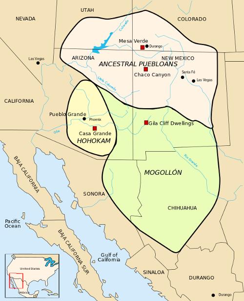 Overview of the three earliest cultures in ArizonaPhoto: Arkyan CC 3.0 Unported no changes made
Many of the Indian tribes in Arizona and nearby states have not been living in this area very long. Nomadic tribes like Navajos and Apaches only arrived between 1300 and 1600 and descend from them. These tribes did not confront the Pueblo and Hopi tribes present, but more or less cooperated and learned things from each other: the Pueblos learned to hunt and the Apaches and the Navajos learned pottery, weaving and farming methods.
In the 16th century, the situation for the Indians would change completely with the arrival of the Spanish explorers, and not for the better!
The Spaniards
In 1536 and 1539 the ee appearedFirst groups of Spaniards in the Arizona area, but in 1540 the first major expedition, from Mexico City, was organized by explorer Francisco Vásquez de Coronado (photo).
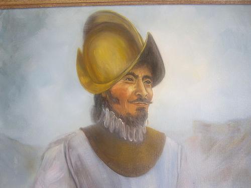 Francisco Vásquez de Coronado (ca. 1510-1554) discoverer of ArizonaPhoto: Billy Hathorn CC 3.0 Unported no changes made
The first Spanish explorers entered the area in February 1540. The expedition, which lasted until about March 1542, consisted of several hundred Europeans and more than a thousand Indians. They had been ordered to search for the riches of the "Seven Mysterious Cities of Cibola," a mysterious and ultimately non-existent kingdom. What was discovered included the Grand Canyon and the Rio Grande. The route De Coronado followed would reach east of present-day Kansas and would later be called the Coronado Trail.
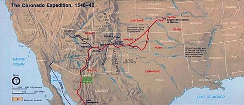 The Coronado Expedition was partially through ArizonaPhoto: Public domain
The Coronado expedition therefore yielded nothing and had only cost a lot of money, so it was not surprising that the Spanish quests for riches in the Southwestern United States for a period of approximately 50 years.
It was not until 1598 that some Spanish activities resumed in the Southwestern United States. Juan de Oñate (ca.1550-1626), a Mexican-born Spaniard, moved north from Mexico with a few hundred soldiers, ca.400 settlers and a number of Franciscan monks. He claimed the area north of El Paso, including present-day Arizona, named it New Mexico and became the area's first governor. Things were not gentle at the time, the Spanish attempts to settle in the hostile Indian territory and convert the Indians to the Catholic faith was often accompanied by violence and bloodshed. Many Indians moved out of the area and Indian revolts also occurred regularly, including in 1680 the northern Pueblo tribes once again took on the Spanish. The Pueblos, with the help of the Hopis, managed to drive more than 2,000 Spaniards off the Rio Grande to El Paso.
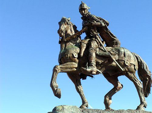 Statue of Juan de Oñate, New Mexico's first governorPhoto: Advanced Source Productions CC 2.0 Generic no changes made
In 1692 the Spaniards fought back and many Pueblos fled to Hopi settlements. Less violent was the case with the Jesuit Eusebio Kino, who eventually gained an almost mythical status as a bearer of the message of God, mainly in southern Arizona. He began his conversions in Mexico in 1687 and stayed in the Arizona-Sonora area for more than 20 years. Among other things, he founded the Tumacácori and San Xavier del Bac missions south of Tucson, Arizona. In addition to the violence and massacres, the Europeans also brought new diseases to America, which led to the death of about 80% of the Indians in the 16th century.
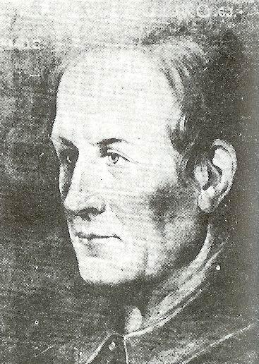 Francisco Eusebio Kino (1645-1711)Photo: copyright expired
Arizona part of the United States
The so-called 'Louisiana Purchase' of 1803 made the United States a large piece of land, from Louisianan to the Rocky Mountains, took over from the French. The territory of the United States doubled with this purchase. The United States' southern border now bordered the Spanish colonies, including Arizona, to the southwest. In 1821 Mexico managed to break away from Spain and became independent. Immediately a trade route was opened between the United States and Mexico, the famous 1500 km long Santa Fe Trail between Missouri and Santa Fe, the capital of the current state of New Mexico. This trade route was used extensively for decades, until a railroad was built in 1879.
In 1846, the United States declared war on Mexico, and after two years of struggle, all the land north ofthe Gila River, which cuts across Arizona, claimed by the United States and incorporated into the New Mexico Territory. Because the most favorable route from the Mississippi to California in the western United States was south of the Gila River, on December 30, 1853, the United States purchased an area of 76,800 km2 south of the Gila River and the current border of Mexico., the so-called Gadsden Purchase. This area was largely through Arizona (image) and the purchase was made between US envoy James Gadsden and Mexican dictator Antonio López de Santa Ana.
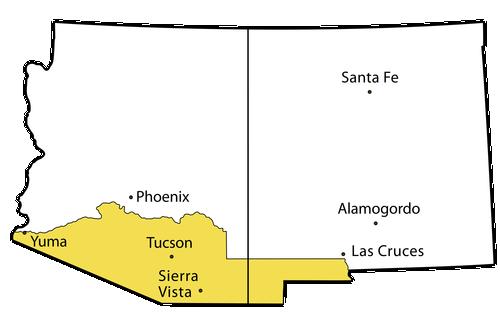 The area purchased by the U.S. from Mexico through the Gadsden purchasePhoto: Public domain
Many of the settlers who moved to this area were from the southern states of the United States and then the American Civil War in 1861, it was therefore not surprising that Arizona joined the Southern States that together formed the Confederacy. In Arizona, the westernmost battle of the entire Civil War was fought at Picacho Peak in 1862. A small group of Confederative soldiers were defeated by a much larger group of soldiers from the Northern States, the Union.
In 1863, Arizona was given status. allocated as a territory, an area with a limited form of self-government and in association with the other 'United States'. Territories were not allowed to elect their own senators and delegates to the US Congress in Washington, D.C. The Arizona Territory was headed by an elected governor, who, however, had little say in Washington. Although Tucson was the largest city, Prescott was chosen as the territory's capital because Tucson was considered a loyal bastion to the Confederatives. From 1867 to 1877, Tucson became the capital of the territory again, then it became Prescott again, and in 1889 another city, Phoenix was definitively chosen.
Also in Arizona, the Indians had it from the early 18th century. century very difficult with American troops, led by Kit Carson, advancing further west, all the while exterminating or chasing down entire tribes that stood in their way. In Arizona, the most far-reaching action was to forcibly relocate most of the Navajos in 1864 to remote Canyon de Chelly in northeastern Arizona. Great famine forced about 9,000 Navajos to migrate east, the Navajos called it 'The Long Walk', towards a camp at Bosque Redondo, near Fort Summer in New Mexico.
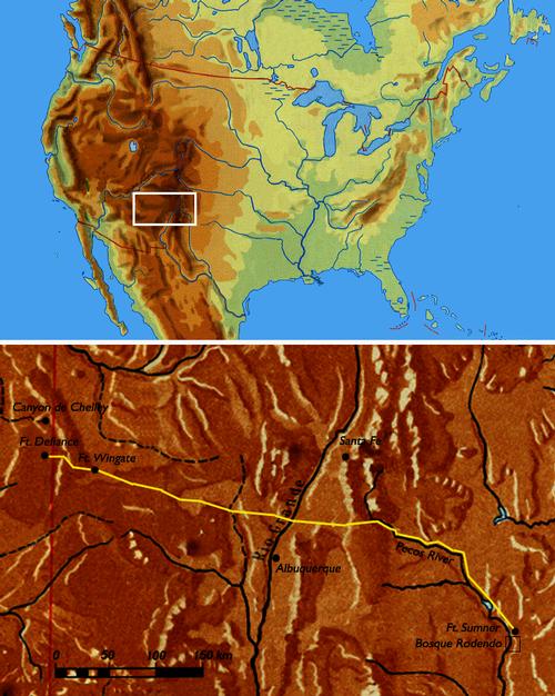 Route of the 'Long walk' in ArizonaPhoto: Günter Strube CC 3.0 Unported no changes made
Hundreds of Navajos died of starvation, disease or were shot along the way. But the stay in Bosque Redondo was also a disaster, more than 2000 Navajos were killed. Four years later, the Navajos were allowed to return to their land in northeastern Arizona and were assigned a 13,000 km2 reservation. In 1868, the treaty was amended to extend the area to 27,000 km2 in Arizona, New Mexico and Utah, making it the largest Indian reservation in the United States. The Apaches continued to resist the American forces to the last, under the leadership of well-known Indian leaders such as Mangas Colorados, Cochise, Victorio and lastly Geronimo.
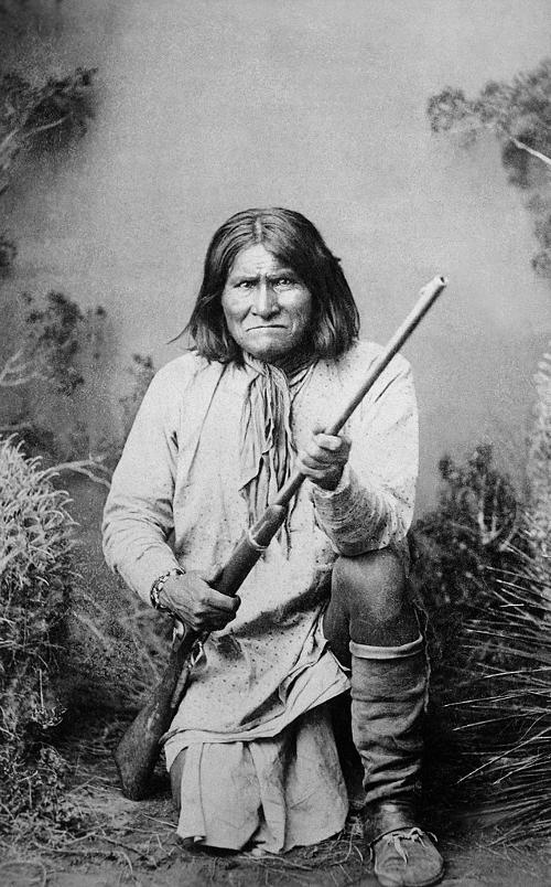 Geronimo (1829-1909 ) Indian leader of the Chiricahua Apaches Photo: U.S. National Archives and Records Administration CC4.0 International no changes made
Geronimo finally surrendered in 1886, after being assured that the Apaches could return to their former homelands after two years of imprisonment. But this promise was also broken, the Apaches would ultimately only be released from their captivity after 27 years. Geronimo's surrender did end the American Indian wars.
In the 1960s, the increasing number of livestock shipments brought to Arizona the cowboy and ranch culture that still characterizes this US state. At first the meat was still sold to the Indians, but soon a large 'own' market was added. Around 1890 werd Arizona was banned from the rest of the country by railroads, and the discovery of gold, silver and copper, among other things, led to the arrival of many fortune-seekers and the creation of countless mining towns. century, Arizona petitioned the federal government to be officially recognized as a state. However, the federal government did not take the request very seriously. Arizona was considered a desolate and lawless desert area where, in the event of becoming an official state of the United States, a bottomless financial pit would arise. That view began to change after a visit by Theodore Roosevelt to Arizona in 1903, who especially admired the impressive landscape. He also promised to begin taming the rivers that often wreak havoc in the spring when they burst their banks. He kept his promise and in 1911 the Salt River Dam No 1 (later the Theodore Roosevelt Dam) was put into use, which ensured that the rivers were regulated and irrigated all year round and clean drinking water was available. A year later, on February 14, 1912, Arizona became the 48th state in the United States.
Modern Arizona owes much to the dams built there during the 20th century;notably the Hoover Dam (1936) in the Colorado River, the Parker Dam (1938) and the Glen Canyon Dam (1966). Glen Canyon Dam and Hoover Dam provide electricity and irrigation water from the gigantic Lake Powell and Lake Mead reservoirs. The Roosevelt Dam is the largest masonry dam in the world, built brick by brick between 1904 and 1911.
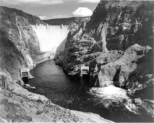 The Hoover Dam in Arizona was Inaugurated in 1936Photo: Ansalm Adams in the public domain
In 1908, the Grand Canyon was designated a National Monument and in 1919 it became an official National Park. During the Great Depression, Arizona was badly hit, but the recovery was soon set in, especially by the developing tourism industry that continues to be of importance to the state to this day. Tourism began in the 1920's and 1930's with resorts for the wealthy in the Phoenix area. Tourism growth was slow but stable. From the start of World War II, tourism was boosted by the influx of military personnel trained in the warm climate of Arizona to fight in climatically difficult conditions in Africa and other warm regions.
After the war, many veterans arrived. returned to Arizona and continued to live there in what a state with many opportunities to have a bright future. Population growth has been spectacular, and cities like Phoenix and Tucson grew rapidly and became nationally important, although disadvantages such as air pollution, crime, and expanding poor neighborhoods did not pass through Arizona's major cities.
In 1959, Arizona became hit by a fairly rare powerful earthquake with a magnitude of 5.6 on the Richter Scale. The epicenter was near Fredonia, Northern Arizona.
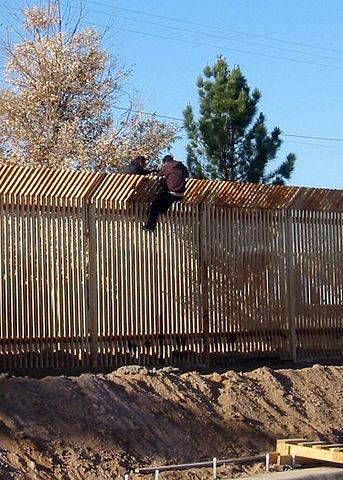 Two illegal men attempting to enter the United States near Douglas, ArizonaPhoto: Public domain
But in general, Arizona is more associated with spas and golf courses, except perhaps on the border with Mexico, where problems with illegal immigrants are almost common. day. In 2009, some 250,000 people crossed the border illegally from Mexico. While this number was much lower than a number of years earlier, very strict anti-immigration laws were passed in 2010, much stricter than in the rest of the United States. For example, the police may arrest anyone they even suspect is illegal in Arizona. was extinguished on July 7. At the time, it was the largest fire that had ever raged in Arizona. Originally there were two fires that over time 'grew' together and eventually 190,000 ha of mainly wooded area would be (partly) destroyed, including about 300 homes. The creation of the Chediski Fire was an accident, the Rodeo Fire was lit.
In 2008, Arizona Senator John McCain became the Republican candidate for President of the United States. He lost the votehowever, from Barack Obama.
 John McCain, Republican presidential candidate for Arizona in 2008Photo: Public domain
May 29, 2011 broke in Eastern Arizona and a small area of Western New Mexico set out a fire that would surpass the 2002 Rodeo-Chediski Fire. The fire would go down in history as the Wallow Fire, named after the area where the fire broke out, the Bear Wallow Wilderness. The fire, caused by an abandoned campfire, broke out in the White Mountains near Alpine town. Nearly 218,000 ha of nature reserve, roughly the size of the province of Limburg, in the counties of Apache, Greenlee, Graham and Navajo was destroyed, as well as 72 buildings. Sixteen people were also injured and 6,000 were evacuated in the largest fire ever to break out in Arizona.
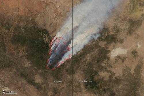 Satellite images Nasa of the Wallow Fire on June 8, 2011 Photo: Public domain
On January 15, 2015, the new Arizona governor, John Ducey, signed an education law requiring high school students to pass a citizenship test with good follow before graduating or obtaining a diploma. Arizona was the first state to make it mandatory.
In October 2015, Arizona was also startled by a deadly shooting on a college campus, now of Northern Arizona University in Flagstaff. One person was killed and three injured in a dorm.
See also the history of the United States.
Sources
Balfour, Amy C. / Arizona
Lonely Planet
Balfour, Amy C. / Southwest USA's best trips : 32 amazing road trips
Lonely Planet
BBC - Country Profiles
CIA - World Factbook
Elmar Landeninformatie
Fodor's Arizona & The Grand Canyon 2015
Fodor's Travel
Heetvelt, Angela / Zuidwestelijke staten van Amerika
Gottmer/Becht
Southwest USA
Lonely Planet
USA-Zuidwest & Las Vegas
Van Reemst
Ward, Greg / The rough guide to Southwest USA
Rough Guides
Wikipedia
Zuidwest-USA
Lannoo
Last updated January 2026
Copyright: Team The World of Info