NOVA SCOTIA

Popular destinations CANADA
| Alberta | British columbia | Manitoba |
| New brunswick | Newfoundland and labrador | Northwest territories |
| Nova scotia | Nunavut | Ontario |
| Prince edward island | Quebec | Saskatchwan |
| Yukon |
Geography and Landscape
Geography
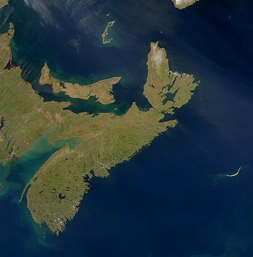
Nova Scotia is one of the Maritime Provinces, a peninsula of over 55,000 km2. Part of Nova Scotia, Cape Breton, is an island, separated from the rest of the province by the Strait of Canso. The rest is connected to the mainland by the Chignecto isthmus.

Landscape
The province is hilly and forms the northern end of the Appalachian Mountains. The coastline is rocky with many coves and islets. Inland there are 400 lakes.
Central Nova Scotia covers the coastline along the Northumberland Strait, where there are many beaches with warm seawater. The coast of the Minas Basin has one of the highest tides in the world with a difference of 15 metres between low and high tide in some places.
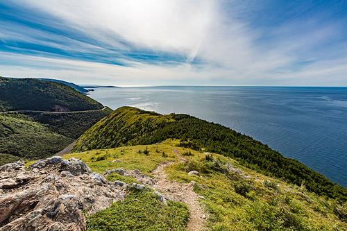
Dartmouth is a city with no less than four hundred lakes and ponds within its borders. The 330-kilometre Lighthouse Route runs along bays, inlets and fjords. Kejimkujik National Park is a reserve with beaches, low tides, salt banks, green forests and lagoons. The town of Amherst overlooks the largest wetland in the world, Tantramar. Cape Breton, Nova Scotia's largest island, is one of the most impressive in Canada in terms of natural beauty. The park stretches across the entire width of the tip of the island. Between the two coasts lies a highland plateau of forests, lakes, marshes and river valleys.
 Coastal Landscape Cape Breton, Nova ScotiaPhoto: Tony Webster CC 2.0 Generic no changes made
Halifax is the capital and the largest city of the province, situated on a huge seaport that is ice-free all year round. Its twin town Darmouth lies on the other side of the bay; the two towns are connected by two suspension bridges.
Climate and Weather
Nova Scotia's maritime climate is of course strongly influenced by the St. Lawrence Gulf in the north, Fundy Bay in the west and the Atlantic Ocean in the south and west.
The waters of the Atlantic Ocean and Fundy Bay are relatively cold (8-12°C), keeping the southwest cool in summer. In January, the temperature is tempered by the same water. The east, south and south-east have to deal with the Warm Gulf Stream (16°C). From January to March, the waters of the St. Lawrence Gulf and the Straits of Northumberland are covered with ice.
Along the coast, the temperature in January averages -4 to -6°C. Summers are relatively cool, around 20°C along the coast and up to 25°C inland.
The wettest place in Nova Scotia is Cape Breton Island with about 1600 mm of precipitation per year. The southern coast also receives about 1550 mm of precipitation per year. The northern coast of the Straits of Northumberland receives less than 1000 mm of precipitation per year.
Precipitation is slightly more frequent in late autumn and early winter. Approximately 15% of all precipitation in Nova Scotia falls as snow, on Cape Breton Island 30%. Along the warm Atlantic coast and around Fundy Bay, a total of about 150 cm falls in winter, inland about 250 cm. The higher areas such as the Cobequid Mountains and the Cape Breton Highlands receive more than 300 cm of snow per year. The snow periods (period with more than 2.5 cm of snow) vary considerably: 110 days along the south coast and 140 days inland.
Snowfall extremes:
in one winter: 653 cm in Cheticamp, 1964-1965
in one month: 224 cm in Cheticamp, 1961
in one day: 69 cm in Yarmouth, 1885
Halifax has a justifiable reputation as a foggy city. Halifax International Airport has about 122 foggy days per year. Other 'foggy' cities are Yarmouth (118 days), Canso (115) and Sydney (80). The period from mid-spring to the beginning of summer is the most foggy.
Because of the many fog days, the number of sun hours is naturally disappointing, between 1700 and 1969 hours per year. Inland, July is the sunniest month; at the coast it is August. The number of sunless days (less than 5 minutes per day) is 75-90 per year, especially in the period November-February. The number of sunny days is 130-160 per year, especially in the period July-October.
Plants and Animals
Digby is the fishing town where the main catch is the scallop. The coastal waters of Long Island and Brier Island are rich in fin whales, minke whales, humpback whales and the rare northern right whale.
Lake Ainslee attracts numerous birds, including ospreys and goldeneyes.
Cape Smokey and Tern Rock, on the Middle Head headland, is a breeding ground for common terns and arctic terns.
Sources
Elmar Landeninformatie
Wikipedia
CIA - World Factbook
BBC - Country Profiles
Copyright: Team The World of Info