AZORES
Geography and Landscape
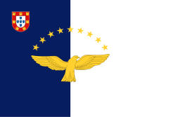
Geography and Landscape
| Basic information | |
| Official language | Portuguese |
| Capital | Ponta Delgada |
| Area | 2.247 km² |
| Population | 242,796 (2019) |
| Currency | euro (EUR) |
| Web | .pt |
| Code. | PRT |
| Tel. | +351 |

Popular destinations PORTUGAL
| Algarve | Azores | Costa de lisboa |
| Costa verde | Madeira |
Geography and Landscape
Geography
The Azores (Portuguese: Açores), an autonomous region of Portugal since 1976, are located in the Atlantic Ocean at a distance of 1448 km from the Iberian Peninsula at the height of the Portuguese capital Lisbon, and about 2300 km from the east coast of North America.
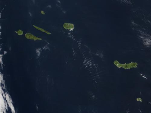
The nine inhabited islands are São Miguel and Santa Maria in the southeast (grupo oriental), Terceira, Pico, Faial, São Jorge and Graciosa in the middle (grupo central), Flores and Corvo in the northwest (grupo ocidental) and the archipelago has a total land area of approximately 2328 km2. The greatest distance between two separate islands, Santa Maria and Corvo, is 585 km;the distance between Faial and Pico is only 8 km.
The eight uninhabited Formigas Islands (official name: Banco das Formigas e Recife do Dollaborat or Ilhas Formigas), 43 km northeast of Santa Maria and south of São Miguel, are also counted among the Azores. The largest island of the Formigas is Formigão.
Distances between all inhabited islands in kilometers
| Santa Maria | São Miguel | Terceira | Graciosa | São Jorge | Pico | Faial | Flores | Corvo | |
| Santa Maria | 0 | 102 | 265 | 345 | 330 | 340 | 360 | 575 | 585 |
| São Miguel | 102 | 0 | 167 | 250 | 250 | 260 | 280 | 500 | 510 |
| Terceira | 265 | 167 | 0 | 57 | 60 | 125 | 122 | 360 | 370 |
| Graciosa | 345 | 250 | 57 | 0 | 40 | 80 | 85 | 270 | 280 |
| São Jorge | 330 | 250 | 60 | 40 | 0 | 20 | 20 | 250 | 260 |
| Pico | 340 | 260 | 125 | 80 | 20 | 0 | 8 | 240 | 250 |
| Faial | 360 | 280 | 122 | 85 | 20 | 8 | 0 | 235 | 245 |
| Flores | 575 | 500 | 360 | 270 | 250 | 240 | 235 | 0 | 28 |
| Corvo | 585 | 510 | 370 | 280 | 260 | 250 | 245 | 28 | 0 |
Corvo is the smallest island with 17 km2, São Miguel is the largest island with an area of 757 km2. Ponta Delgada is the capital and also the largest city and is located on São Miguel. The location of the village of Fajã Grande on the island of Flores is special, because it is officially the most westerly place in Europe. The uninhabited rock island of Ilhéu de Monchique off the west coast of Flores is said to be the most westerly point in Europe.
In the ocean around the islands are also several other uninhabited islands, including the Ilhéu in addition to the eight Ilhas Formigas islands mentioned above. the Vila Franca, the Ilhéu Maria Vaz (Flores), the rocky island of Ilhéu do Romeiro, the rocky island groups Ilheu do Topo and Ilhéus da Alagoa (São Jorge), the two 'goat islands' Ilhéus das Cabras (Terceira), Ilhéu de Baixo (Graciosa) ), Ilhéu da Baleia (Graciosa), Ilhéu Lagoinhas (Santa Maria), the islands of Deitado and Em Pé (Pico) and the bird island Ilhéu de Praia, with the richest and most diverse population of seabirds in the Azores, including many migratory birds.
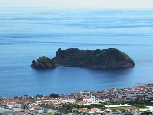 Ilhéu de Vila Franca, uninhabited island from the AzoresPhoto: Lusitana CC 3.0 Unported no changes made
Details of all inhabited islands
| area | distance from mainland | highest point | |
| São Miguel | 757 km2 | 1584 km | 1103 m |
| Pico | 433 km2 | 1,860 km | 2351 m |
| Terceira | 402 km2 | 1764 km | 1023 m |
| São Jorge | 246 km2 | 1,832 km | 1053 m |
| Faial | 172 km2 | 1908 km | 1043 m |
| Flores | 142 km2 | 2152 km | 915 m |
| Santa Maria | 97 km2 | 1588 km | 587 m |
| Graciosa | 62 km2 | 1,844 km | 402 m |
| Corvo | 17 km2 | 2148 km | 718 m |
Landscape islands
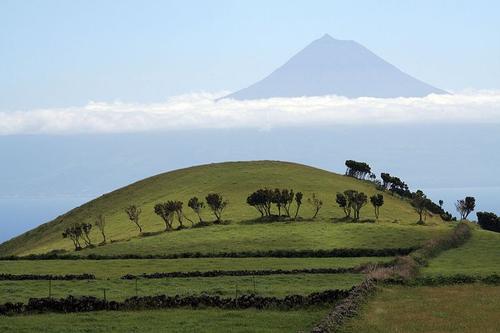 Azores LandscapePhoto: Björn Ehrlich CC 3.0 Unported no changes made
São Miguel
Ilha de São Miguel, the largest island of the Azores (757 km2, length maximum 64 km, width maximum 17 km, coast length 220 km) and together with Santa Maria belonging to the grupo oriental, has many volcanic phenomena and is geologically about 4 million years old. São Miguel actually consists of two islands that only joined together 50,000 years ago. The nearest islands are Santa Maria at 102 km and Terceira at 167 km.
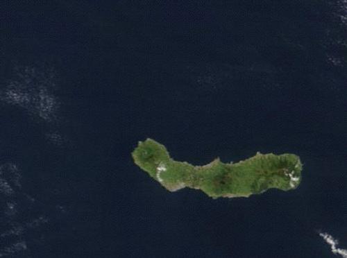 São Miguel satellite photoPhoto: Public domain
Huge craters are filled with lakes and there are healing thermal springs scattered around the island. São Miguel is also called the 'Ilha Verde', the 'green island';especially the central part of São Miguel is very green and fertile. São Miguel has three so-called stratovolcanoes (Sete Cidades, Água de Pau and Furnas), high cone-shaped volcanoes made up of layers of solidified lava and tephra. These types of volcanoes have steep slopes and are characterized by frequent explosive eruptions. Between the Sete Cidades and Fogo, there is a monogenetic (one eruption, then never active again) so called by geologists a volcanic area with 270 volcanoes.
Famous are the crater lakes in one of the largest craters in the Azores, the Caldeira das Sete Cidades (circumference 12 km), especially the two largest lakes, Lagoa Azul, the 'blue lake' and Lagoa Verde, the 'green lake'. The two special colors are caused by the algae and water plants, which provide the green color in the smaller lake Lagoa Verde. The crater is at its widest 5 km in diameter, and the highest mountain of the crater rim is Pico das Éguas (873 m). The highest mountain in São Miguel, located in the Serra da Tronqueira, is Pico da Vara (1103 m), the second highest mountain is Pico da Barrosa (947 m). Lagoa das Furnas is the second largest lake in São Miguel with an area of 1.9 km2, a length of 2 km, a width of 1.6 km and a depth of 12 meters. The thermal springs on the shores of the lake reach a temperature of 61.5°C.
The Ribeira Grande is the wildest river in São Miguel and is therefore used for generating electricity. Other rivers and streams are the Ribeira Quente, Ribeira do Faialda Terra, Ribeira da Praia, Ribeira das Barrelas, Ribeira das Très Voltas, Ribeira do Cachaço, Ribeira do Guilherme, Ribeira do Mato, Ribeira Purgar, Ribeira dos Pelanos, Ribiera dos Migueis and Ribaira Funda. After Lagoa Azul and Lagoa Verde, Lagoa do Fogo is the largest crater lake in São Miguel. Other crater lakes are the Lagoas Empadas, the Lagoa do Canário, the Lagoa do Fogo (the highest lake in São Miguel at an altitude of 570). Waterfalls, often in hidden places, include the Salto do Cagarrão, Salto do Prego and Salto do Cabrito.
Santa Maria
The other island of the grupo oriental is Santa Maria (capital Vila do Porto), which was the first island of the Azores to be colonized by the Portuguese and is geologically the oldest island in the Azores with a respectable age of 8-10 million years. Santa Maria, also known as the 'yellow island', is also the only island of the Azores where fossils have been found.
With an area of 97 km2, Santa Maria is the third smallest island in the Azores;Santa Maria is maximum 16 km long, 10 km wide and has a coast length of 76 km. Santa Maria is the southernmost island of the Azores and is the closest of all the islands to Portugal. The nearest island, São Miguel, is at 89 km.
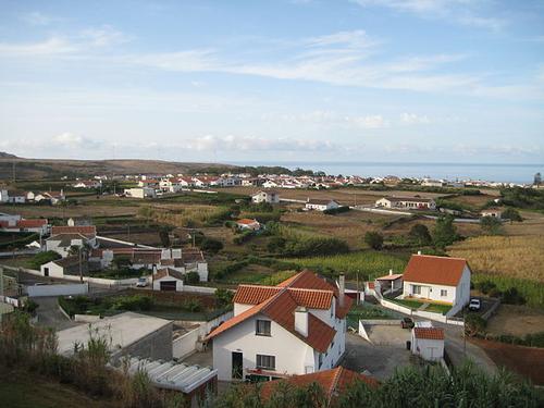 Parohie Vila do Porto in the capital of the same name Vila do Porto Photo: Julen Iturbe-Ormaetxe CC 2.0 Generic no changes made
Santa Maria is not at all touristy yet, although the climate is very mild and sunny. The coasts could also appeal to tourists, one even speaks of the coastal strip with its white beaches, quite unique for the Azores with its predominantly black beaches, as the 'Alsheaf of the Azores, although much of the coasts descend steeply to the sea.
The interior of Santa Maria, which is no longer volcanically active, is hilly and covered with green pastures. In the central mountain range of Santa Maria, covered with Japanese cedars, tree heather, juniper and laurel, lies the highest peak of the island, Pico Alto (587 m). During the rainy months, the Cascata do Aveiro waterfall is a tourist highlight, as is the Foz da Ribeira Grande waterfall. The barely inhabited northwest coast of Santa Maria, the Barreiro da Faneca, consists of a semi-desert landscape with clayey red soil and is called the 'red desert' of the Azores. The west of Santa Maria is generally flat and in the summer this area turns into an arid steppe-like landscape, where agaves and cacti predominate. The sparsely populated east of Santa Maria is hilly and green.
Some rivers are the Ribeira do Engenho, Ribeira de Santa Bárbara, Ribeira do Salto, Ribeira Grande, Ribeira do Amaro and Ribeira do Cachaço.
Faial
Faial (grupo central) is with an area of 172 km2 the fifth largest island in the Azores, has a length of 21 km, a width of 14 km and the coast length is approximately 80 km. The nearest island, Pico, is only 8 km. Faial is not a very pleasant place to live;the island's history is interspersed with volcanic eruptions and severe earthquakes, up to the 20th century. For example, in 1998 much of the buildings in eastern Faial were destroyed. Furthermore, the once wooded island now consists largely of grassland and meadows with some bushes here and there.
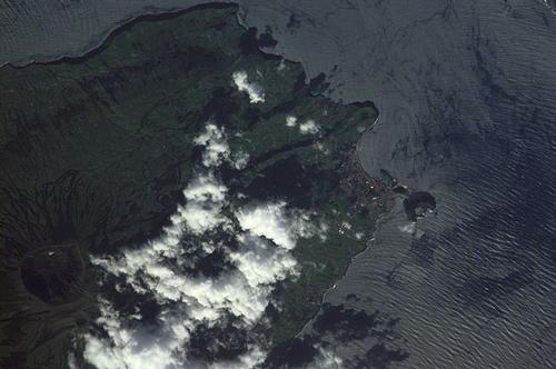 Satellite photo of part of Pico, with the Caldeira crater on the leftPhoto: Public domain
Nevertheless, Faial is a real tourist island and owes its nickname 'ilha azul', the 'blue island', to the flowering period of the hydrangeas, which sometimes cover entire hills. In the west of the island, on the Capelo peninsula, is the youngest volcano in the Azores, the Vulcão dos Capelinhos. The eruption created approximately 2.5 km2 of new land (two-thirds of the original surface has already disappeared due to the powerful surf), which has a desert-like character but after many years finally shows some vegetation. To the west of Castelo Blanco, just off the coast, there is a huge rock (about 150 meters high), the Morro de Castelo Branco, made of the volcanic rock trachyte.
The south coast of Faial is steep with caves and rock arches. Special is the gigantic Caldeira crater, 400 meters deep with steep walls and a diameter of 1450 meters. The entire crater area belongs to the Reserva Natural da Caldeira do Faial. The highest point in Faial is Cabeço Gordo (1043 m). The north coast is a rural agricultural area with many meadows right up to the slopes. To the west of this area is the wooded Zona do Mistério. The former volcano Monte da Guia overlooks the city of Horta and the caldiera do Inferno crater is filled with seawater.
Pico
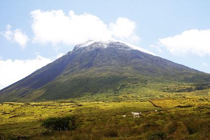 Montanha de Pico, highest mountain in the Azores on the island of PicoPhoto: José Luís Ávila Silveira/Pedro Noronha e Costa in the public domain
Pico (grupo central) is with an area of 422 km2 the second largest island of the Azores with a maximum length of 46 km, a maximum width of 16 km and a coast length of about 147 km.
The very special landscape of the par excellence volcanic island of Pico, the 'Ilha Montanha' (the mountainous island), is completely dominated by the volcano Montanha de Pico, which forms a height of 2351 meters. This makes the volcano not only the highest point in the Azores, but also in all of Portugal. The central crater of the Pico is called the Pico Grande and has a diameter of about 700 meters. Inside the crater is a volcanic cone, the Pico Pequeno, which rises about 50 m above the crater rim of the Pico.
Remarkable in the landscape of Pico are the so-called 'mistérios', congealed lava flows that after centuries are covered with fertile soil and are therefore hardly usable for agriculture. What remains is a rocky landscape where only a few lichens grow, interspersed with dense areas. The most recently created mistério dates from 1720. Also special are the stone heaps or 'maroiços' that can be found mainly on the west coast of Pico. These lava heaps were created when the inhabitants of Pico wto create mining land and are now part of Pico's protected history.
The Gruta das Torres is a volcanic tunnel complex over five kilometers long and up to 15 meters high beneath a solidified lava flow, one of the longest volcanic tunnels in the world. More than 80 other, albeit smaller, volcanic caves can be found on Pico, including the Furna de Frei Matias and the Gruta das Canárias.
The eastern point of Pico is suitable for agriculture, with the village Piedade as its center. The central and eastern mountain area of Pico is called the Planalto Central or Planalto da Achada, an almost uninhabited plain up to 800 meters high with a number of crater lakes (including Lagoa Seca, Lagoa do Caiado, Lagoa do Paul and Lagoa Peixinho), flat volcanic cones and a mountain ridge with a series of extinct volcano peaks, including the Grotões (1008 m), the Cabeço Escalvado (1004 m) and the Caveiro (1076 m). In total Pico has about a hundred volcanoes. The Lagoa do Caido is the largest lake on the Planalto Central, the largest crater lake in Pico is the Lagoa do Capitão. The western coastal region descends much less steeply in many places and here is the harbor town of Madalena.
São Jorge
São Jorge, next to the island of Flores, a true hiking paradise with many coastal paths and other hiking routes, is with 246 km2 the fourth largest island of the Azores, has a maximum length of 55 km, a narrow maximum width of 7 km and a coast length of approximately 140 km. São Jorge is located 35 km south of Graciosa, 17 km north of Pico, 26 km east of Faial and 52 km west of Terceira.
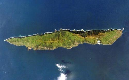 São Jorge satellite photoPhoto: Public domain
São Jorge (grupo central) is a 'green' island with beautiful nature, volcano tops, meadows, steep cliffs and very narrow built-up coastal plains, the 'fajãs', of which 46 can be found on São Jorge, 30 on the north coast and 16 on the south coast. The houses on most fajãs have been abandoned over time, especially after the 1980 earthquake, only the larger fajãs are still inhabited. The central mountain ridge of São Jorge, Serra do Topo, has as its highest peak the Pico dos Frades (942 m) and further strings one volcano crater after another. The fertile highland of the island, with an average altitude of 700 meters, is used for grazing cattle and there are also a number of waterfalls in this area.
The north coast of São Jorge is rugged with almost vertical cliffs of 700 meters high, making the coastal plains quite inaccessible and sometimes only accessible on foot. Here you can also find the highest peaks of São Jorge, the 1053 meter high Pico da Esperança and the 1019 meter high Morro Pelado. São Jorge has several rivers and streams, including Ribeira do Belo, Ribeira do Almeida, Ribeira das Queijades, Ribeira da Casa Velha, Ribeira do guadalupe, Ribeira do Jogo, Ribeira do Ferro, Ribeira do Capadinho, Ribeira dos Vimes, Ribeira do Cavalete, Ribeira dos Cedros, Ribeira de São João, Ribeira dos Bodes and Ribeira Funda.
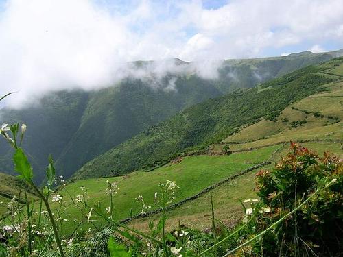 Green landscape in São Jorge, AzoresPhoto: José Luís Ávila Silveira/Pedro Noronha e Costa in the public domain
Terceira
Terceira is with an area of 402 km2 the third largest island of the Azores, after São Miguel and Pico. The maximum length of Terceira is 30 km, the maximum width is 18 km and the coast length is 124 km. The nearest islands are São Miguel at 145 km and Faial at 106 km.
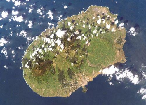 Satellite Photo TerceiraPhoto: Public Domain
Terceira (grupo central) is a volcanic island with a variety of volcanoes, volcano pipes, lava caves, crater lakes (including Lagoa das Patas, Lagoínha da Serreta, Lagoínha do Vale Fundo, Lagoa do Negro), lava tunnels, congealed lava flows, fumaroles, sulfur fumes and steam vents. You can swim in the many lava pools. The west of Terceira, with much more forests than in the east of the island, is completely dominated by the massif of the last active and youngest volcano of Terceira in 1762, the Serra de Santa Bárbara, with a height of 1023 meters also the highest point of Terceira. To the northeast of this lies a vast forest area, Mata da Serrata.
In the northeast of Terceira lies the mountain ridge Serra do Cume, from where you have a good view of the bay and the long sandy beach at the place Praia da Vitória. The north of Terceira is generally rugged and inaccessible with volcanic caves such as Furna das Pombas, with the exception of the coastal plain of Alagoa da Fajãzinha, a rural area where wine-growing is possible. This plain, located between the Serra do Cume and the Serra da Ribeirinha, is the largest plain in the entire Azores archipelago. The oldest volcano of Terceira is the Cinco Picos, the caldera of this volcano that collapsed 300,000 years ago, with a diameter of 7 km, is the largest of the Azores.
In the central highlands there are primeval forests, volcanic caves (including Gruta do Natal, Algar do Carvão), fumaroles (including Furnas do Enxofre), but especially countless volcanoes. Also special here are the Mistérios Negros, black lava hills that were created after the eruption of the Santa-Bárabara volcano in 1761. The Terra Brava, the 'wild land' is characterized by a large number of bull pastures. Biscoito das Fontinhas is a densely wooded lava field with deeply carved ancient wagon tracks or 'relheiras'. The Pico Alto is the second highest peak in Terceira at 808 meters.
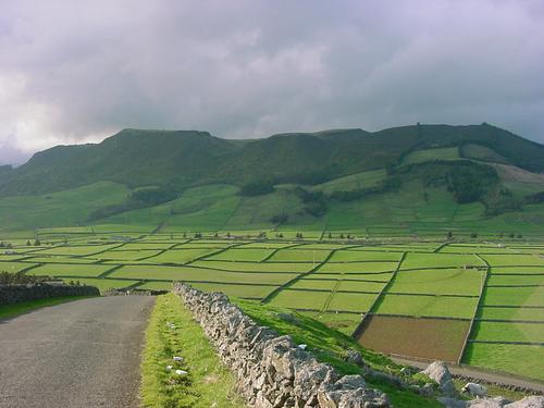 Nature and agriculture side by side Terceira Island, AzoresPhoto: Public domain
Graciosa
Graciosa (grupo central) is the second smallest island of the Azores, Corvo is the smallest island, with an area of only 62 km2, a maximum length of 12 km, a maximum width of 8 km and a coastal length of 43 km. Graciosa in its entirety has been declared a UNESCO Biosphere Reserve. The nearest island is Terceira at 50 km.
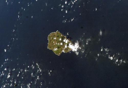 Satellite photo Graciosa, AzoresPhoto: Public domain
Three mountain ridges can be distinguished across the island, the Serra Dormida, the Serra Branca and the Serra das Fontes. Striking is the mountain range in the southeast of Graciosa with the Caldeira and the enormous volcanic (sulfur) cave Furna do Enxofre, the Furna do Abel and the somewhat smaller volcanic tunnel Furna da Maria Encantada. The crater rim of the Caldeira is a maximum of 402 meters high, 1600 meters long and 800 meters wide, and this is the highest point of Graciosa. Other 'peaks' are the Pico Timão (398 m) and the Pico do Facho (375 m). The Furna do Enxofre is 95 meters deep and 130 meters wide and houses a small crater lake about 22 meters below sea level, the Lagoa do Styx. The fairly flat northwest of Graciosa is characterized by meadows and vineyards.
The village square of the capital Santa Cruz da Graciosa is surrounded by gigantic New Zealand Christmas trees that were planted as far back as the 19th century.
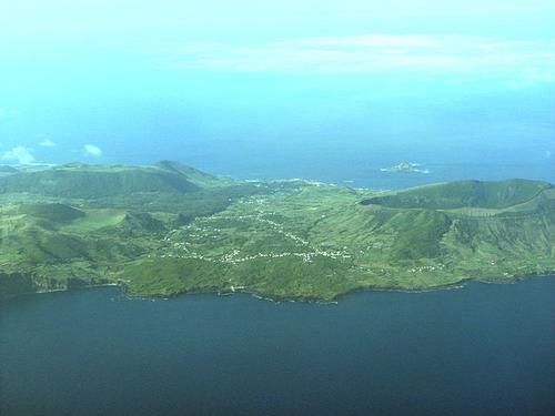 Caldera of Graciosa, AzoresPhoto: Angrense in the public domain
Flores
Besides the 'flower island', Flores is also the most scenically rugged but also the most beautiful island of the Azores with many mountains, valleys, crater lakes, waterfalls and very steep up to 600 meters high cliffs. Flores is also the westernmost and fourth smallest island of the Azores with an area of 142 km2. Flores has a maximum length of 17 km, a maximum width of 12 km and a coast length of approximately 72 km. Flores is unique to the Azores because, unlike the other islands, it has no caldera and no long gorges. And just like Corvo, Flores lies between two tectonic plates and therefore has no earthquakes.
Flores, together with the small Corvo, belongs to the western group (grupo ocidental) inhabited islands of the Azores and, like the island of Graciosa, is UNESCO declared a biosphere reserve. Like Corvo, Flores belongs geologically to America, because it lies on a North American plate and slowly drifts towards the American mainland. In general, Flores has a rugged, steep and therefore inaccessible rocky coast in the west, where, especially in the winter months, many waterfalls fall down;there are also surf caves such as Gruta dos Enxaréus and Gruta do Galo. Many waterfalls can also be found further inland, including Lake Poço das Patas to the east of the town of Fajãzinha, which is fed by many waterfalls of the Ribeira do Ferreiro. One of Flores' mountain streams, the Ribeira das Casas, flows into the 90-meter-high Cascata do Poço do Bacalheu waterfall. TheRibeira das Casas has its source on the highest peak of Flores, the Morro Alto (915 m).
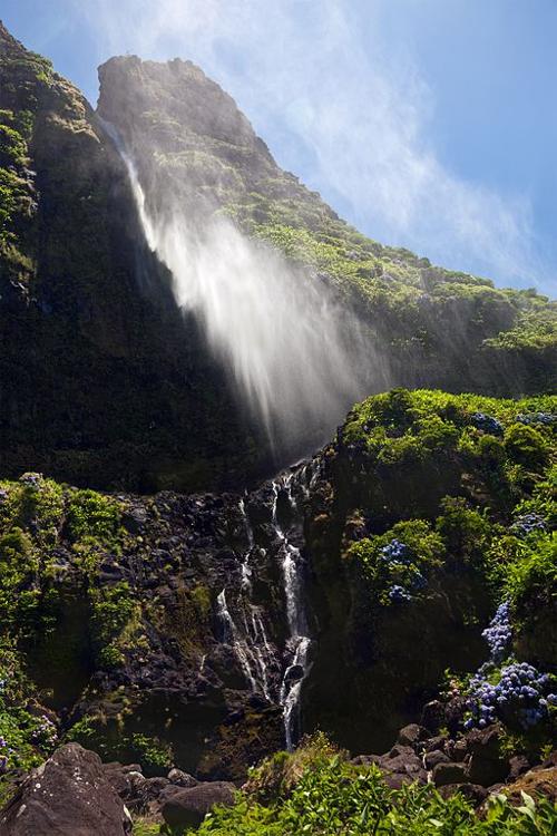 Waterfall 'Cascata do Poço do Bacalhau' in Flores, AzoresPhoto: Unukorno CC 3.0 Unported no changes made
Other high peaks on Flores are the Pico da Burrinha (886 m) and the Pico dos Sete Pés (849 m). The steep slopes of the green west coast, which can be hundreds of meters high, are covered with forests and meadows. The mountainous interior of Flores is characterized by the presence of forests, swamps, crater lakes, volcanic cones, and is brightened by juniper bushes and hydrangea hedges. The entire east side of Flores is cut through deeply cut valleys. The rock formations on the Ponta da Caveira headland are rugged and spectacular.
The crater lakes area is called Sete Lagoas, the 'seven lakes'. The seven lakes are Lagoa da Lomba (15 m deep), Lagoa Comprida (17 m deep), Lagoa Negra (the deepest lake, 105 m), Lagoa Seca (seca = dry, so the lake with the least water), Lagoa da Água Branca (very shallow, 2 m), Lagoa Funda (22 m deep) and Lagoa Rasa (16 m deep). The basalt massif Rocha dos Bordões is impressive.
In addition to the aforementioned rivers Ribeira do Ferreiro and Ribeira das Casas, Flores has a number of rivers and streams: Ribeira do Mouco, Ribeira da Badanela, Ribeira Grande, Ribeira da Lapa, Ribeira do Monte Gordo, Ribeira Funda, Ribeira da Esguilhão, Ribeira da Fazenda, Ribeira da Silva, Ribeira do Loureiro, Ribeira Seca, Ribeira da Lapa, Ribeira do Fundão, Ribeira do Mosteiro, Ribeira da Caldeira, Ribeira Grande, Ribeira do Pomar, Ribeira das Lajes, Ribeira d'Além, Ribeira do Moinho and Ribeira da Privada.
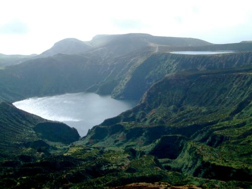 Lagoa Funda, with in the background Lagoa Rasa, Flores, AzoresPhoto: Luisa Madruga CC3.0 Unported no changes made
Corvo
Corvo or the 'crow island' is the smallest inhabited island of the Azores with an area of only 17 km2 The maximum length of Corvo is 6.5 km, the maximum width is 4 km and the coast length is approximately 21 km. Geologically, Corvo belongs to North America, as it is located on the North American continental plate.
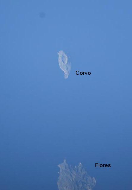 Satellite photo of Corvo, AzoresPhoto: Public domain
The landscape of Corvo (grupo oriental) is totally dominated by the gigantic and only crater (275 m deep and a diameter of 2000 m) in the middle of the island, the Caldeirão. In the crater, one of the largest in the Azores, meadows have been created and cows graze there. The highest points of the crater rim are in the south Morro dos Homens (718 m), also the highest point of Corvo, and in the north Serrão Alta (663 m). At the bottom of the crater is an eight-shaped lake.
Some streams on Corvo are the Ribeira Funda, the Ribeira do Poco de Agua, Ribeira da Lapa and the Ribeira da Fonte Doce. Corvo has the highest cliffs in the Azores, up to 700 m high, especially in the north and northwest of the island.
Volcanism
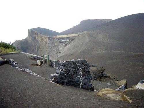 Volcanic rock for the volcano Capelinhos, AzoresPhoto: Feliciano Guimarães CC 2.0 Generic no changes made
The Azores archipelago is unmistakably of volcanic origin, with the formation of the youngest volcano in 1957-1958 and the last major earthquake in 1998 with deaths, injuries and nearly 20,000 homeless.
The Azores are basically mountain peaks of an underwater mountains that rise above the ocean. hot liquid magma flows continuously at the bottom of the ocean and solidifies as soon as it comes into contact with the much colder seawater. This continuous supply of new rock ensures that the continents of Europe and Africa and America on both sides of the Atlantic Ocean are being pushed apart at a rate of 1 cm per year. This plate tectonics is causing the western archipelago, Flores and Corvo, to move awayof the other islands of the archipelago and is no longer a volcanically active area.
The islands of the 'Grupo Central' and the 'Grupo Oriental', on the other hand, except Santa Maria, are very volcanic. These two groups of islands are sandwiched between a number of large continental plates and there are still frequent eruptions and earthquakes. The youngest volcano, Capelinhos, was born in the years 1957-1958 and quite 'heavy' earthquakes still occurred in 1980 and 1998, the latter having a magnitude of 5.6 on the Richter scale and killing eight people from Faial Island. More than 3,000 aftershocks were recorded in the weeks after the great quake. In total, the archipelago has been hit by more than thirty major volcanic eruptions since colonization in the 15th century, and often devastating earthquakes in connection therewith.
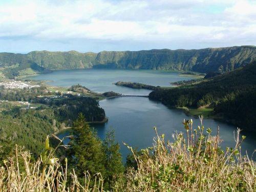 Caldeira das Sete Cidades on Sao Miguel, AzoresPhoto: Ulrik Sverdrup CC 3.0 Unported no changes made
A variety of volcanic activity can also be observed throughout the Azores, including mud volcanoes, hot water springs and fumaroles, holes or crevices in the bottom from which volcanic effluents with temperatures between 100 and 1000°C escape. If hydrogen sulphide stinking like rotten eggs is present, fumaroles are called solfatars.
In addition, there are many caves on the islands, sometimes formed from a fumarole, and craters. Crater walls collapse due to eruptions and so 'caldeiras are created, including on São Miguel de Caldeira das Sete Cidades and on Faial de Caldeira. There are two types of caves on the archipelago: lava tunnels (for example, the Gruta do Carvão which cuts through Ponta Delgada for a length of 1,650 meters) under cooled lava flows and a series of cracks called crater pipes, which connect to a magma chamber deep in the ground. Shapes such as lava cones, basalt stalactites and quartzite drip stones can be found in tunnels as well as in craters.
In the coming decades, energy production from geothermal energy will become increasingly important for the Azores. At the moment, about 22% of the electricity comes from a number of geothermal power stations, on the largest island of São Miguel, that percentage is already reaching 50%. Although there are also possibilities to extract geothermal energy on the other islands, this is not happening yet.
Sources
BBC - Country Profiles
CIA - World Factbook
Elmar Landeninformatie
Lipps, Susanne / Azoren
ANWB
Marsh, Terry / Azores
New Holland
Martin, Roman / Azoren
Elmar
Sayers, David / Azores
Bradt Travel Guides
Stieglitz, Andreas / Landscapes of the Azores : a countryside guide
Sunflower Books
Wikipedia
Copyright: Team The World of Info