BHUTAN
Geography and Landscape

Geography and Landscape
| Basic information | |
| Official language | Dzongkha |
| Capital | Thimphu |
| Area | 38,394 km² |
| Population | 779,898 (2021) |
| Currency | ngultrum (BTN) |
| Web | .bt |
| Code. | BTN |
| Tel. | +975 |
Geography and Landscape
Geography
The kingdom of Bhutan (officially Druk Yul = Land of the Dragon;also known as Druk Tsendhen = Land of the Thunder Dragon) is located in Southeast Asia between China (Tibet) and India and nowhere borders the sea.
Bhutan is bordered to the north and northwest by Tibet (470 km, regions Dromo, Khangmar, Lhodrak and Tsona) and is completely enclosed by Indian states, a total of 699 km: to the east by Arunachal Pradesh (217 km), to the south by Assam (267 km) and West Bengal (183 km) and to the west by Sikkim (32 km). The southern part of Bhutan is officially located on the Indian subcontinent. It is only possible to enter Bhutan via the border with India, the border with China is completely closed.
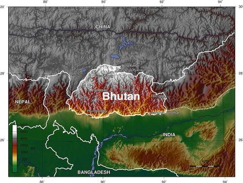 Bhutan Satellite PhotoPhoto: Public Domain
Bhutan has a maximum width of 150 km and a maximum length of 300 km and the area of Bhutan is approximately 46,500 km2.
Landscape
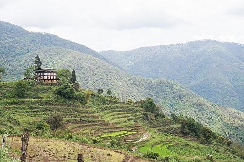 Bhutan LandscapePhoto: Bernard Gagnon CC 4.0 International no changes made
Bhutan, located in the eastern Himalaya Mountains, consists almost entirely of mountain land, making it one of the most relief-rich countries in the world. Only on the border with India it is somewhat flatter with a height of only 97 meters above sea level, the lowest point in the country is Drangeme Chhu. After that, however, the height rises very quickly to more than 7500 in the north, with the Gankhar Punsum as the highest peak (7541 m) which lies entirely in Bhutan. Higher is the Kulha Gangri (7554 m), but it lies partly in the Tibetan region of Lhodrak. Mountain climbers have a hard time with Gankhar Punsum as it is still the highest mountain in the world that has not been conquered by anyone.
Other high mountains in Bhutan are Liangkang Kangri (7534 m), Cho-mo-la-li Shan (7,314 m), Kangphu Kang I (7,220 m), Tongshanjiabu (7,207 m) and Chomolhari Kang (7,121 m). Bhutan does not have a single mountain higher than 8000 meters, but it does have 21 peaks higher than 7000 meters. Most of Bhutan consists of low mountain ranges with an altitude between 1100 and 4000 meters. Bhutan's highest mountain pass, Thumsingla Pass, is located at an elevation of 3,800 meters in eastern Bhutan.
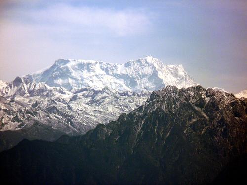 Gangkhar Punsum, highest mountain in BhutanPhoto: Dhaag23 CC 2.0 Generic no changes made
Besides an unmistakable mountain landscape, Bhutan is also largely covered with forests. And it always will, if it is up to the government of Bhutan. The law stipulates that the surface of Bhutan must consist of at least 60% forest.
Bhutan can be roughly divided into four landscapes. To the north is the "Great Himalaya", the highest central mountain range in the Himalayan range, running from Chomo Lhari in the west to Phameleja in the east. Here are many peaks of more than 6000 m, covered with eternal snow and glaciers. Approx. 20% of Bhutan is continuously covered with eternal snow. Many mountain peaks have not or hardly been climbed and sometimes do not even have a name. Between these impressive peaks there are valleys at an altitude of at least 3500 m with tundra-like vegetation. The Great Himalaya is intersected by only one valley, namely that of the Kuru Chhu (Lhobrak). including Thimphu, Paro, Haa, Bumthang, Tongsa and Punakha), often at altitudes between 1500 and 2700 m.
This area also contains all the major cities of Bhutan. The most striking chain is the Black Mountains, a somewhat mysterious area of about 1400 km2 with deep ravines the main barrier between East and West Bhutan. A road runs through the passes from the east to the west at an altitude of more than 2000 m. Differences in height and location with respect to monsoon winds provide a vegetation that varies from dense cloud forests to tundra vegetation. the Black Mountains range in elevation from 700 meters in the south to 4,600 in the central area. The highest mountain in the Black Mountains is Dungshinggang (or Mount Jow Durshing), 4617 meters high and consisting of three peaks, the 'Three Brothers Peak'.
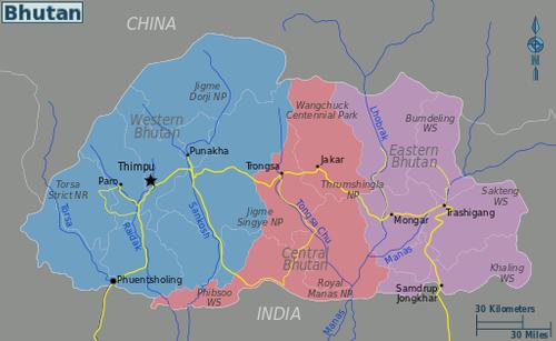
Map of Bhutan regionsPhoto: Public domain
The ends of the Inner Himalayan mountain ranges are called 'Outermost Ranges' and form a distinct small landscape. The Outermost Ranges rise from the Duar Plain to 600 meters and then rise through steep walls or escarpments to a height of 1500 meters. A number of rivers or 'chhus' flow through the Outermost Ranges through deep canyon valleys. . The 18 "duars" are the fertile valleys between two river valleys. Depending on the permeability of the soil, long grass or dense rainforest grows here.
Bhutan has four major unnavigable river systems, the Amo-chhu, the Kuri-chhu, the Gamri-chhu and the Thimphu-chhu . The enormous hydropower potential of these river systems makes a significant contribution to the Bhutanese economy. Bhutan's largest river is the Manas or Drangme-chhu. All the rivers of Bhutan flow through the 'duars' or 'dooars' towards Brahmaputra in India. Other rivers are Di-chhu, Wang-chhu, Punatsang-chhu, Mangde-chhu, Bumthang-chhu, Kulong-chhu, Tawang-chhu, Bada-chhu and Dhansiri-chhu.
Bhutan has 618 glaciers and and 2664 glacial lakes (above 3500 meters altitude). The recent flooding of several glacial lakes is alarming. This has everything to do with global warming, the lakes are filled with millions of cubic meters of melt water and then cause floods because the water has nowhere to go. In 1994, a glacial lake in the Po Chhu River overflowed and devastated a number of villages, killing 23 people. At present, several dozen lakes pose a direct danger to humans and animals.
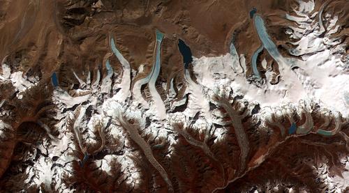 Glacial Lakes of BhutanPhoto: Public domain
Main glacial lakes of Bhutan
| lake | district | lake | district |
| Thorthormi Glacial Lake | Gasa | Gangchentag Glacial Lake | Gasa |
| Raphstreng Glacial Lake | Gasa | Wochey Glacial Lake | Gasa |
| Luggye Glacial Lake | Gasa | Teri Kang Glacial Lake | Gasa |
| Bechung Glacial Lake | Gasa | Chubda Glacial Lake | Bumthang |
| Roduphu Glacial Lake | Gasa | Taksha Tsho Glacial Lake | Gasa |
| Sinchhe Glacial Lake | Gasa | Tsokar Glacial Lake | Bumthang |
In addition to the thousands of glacial lakes, there are also dozens of 'ordinary' Lakes, which can generally be found above a height of 3500 meters. Only four lakes are below an altitude of 2000 meters: Ho Ko Tsho (at an altitude of 1829 meters), Luchika Tsho (1830 meters), Buli Tsho (1372 meters) and Gulandi Tsho (366 meters).
Main mountain lakes of Bhutan:
| lake | district | lake | district | lake | district |
| Animo Tsho | Bumthang | Ho Ko Tsho | Punakha | Rigona Tsho | Paro |
| Buli Tsho | Zhemgang | Janye Tsho | Thimphu | Sertsho | Thimphu |
| Chhiba Tsho | Dagana | Jatsho | Thimphu | Sethag Burge Tsho | Gasa |
| Chungge Tsho | Bumthang | Jimilang Tsho | Thimphu | Setsho | Gasa |
| Dagebho | Thimphu | Laname Tsho | Paro | Simdong Goi Tsho | Gasa |
| Daja Tsho | Thimphu | Langtsho | Dagana | Simk otra Tsho | Thimphu |
| Djule Tsho | Bumthang | Luchika Tsho | Wangdue Phodrang | Solang Chhu | Bumthang |
| Dongney Tsho | Paro | Membar Tsho | Bumthang | Tampoe Tsho | Trongsa |
| Dongtsho | Thimphu | Ngyetsho | Thimphu | Tshochena Lake | Gasa |
| Dungtsho Tsho | Paro | Nob Tshona Patta Tsho | Haa | Tsho Phu | Paro |
| Gulandi Tsho | Jongkhar | Om Tsho | Trongsa | Utsho Tsho | Thimphu |
Sources
BBC - Country Profiles
Brown, Lindsay / Bhutan
Lonely Planet
CIA - World Factbook
Dorje, Gyurme / Bhutan Handbook
Footprint
Elmar Landeninformatie
Jordans, Bart / Bhutan : a trekker's guide
Cicerone
Pommaret, Françoise / Bhutan : Himalayan mountain kingdom
Odyssey
Te gast in Bhutan
Informatie Verre Reizen
Copyright: Team The World of Info