PALAU

Geography and Landscape
Geography
Micronesia (from the Greek: small islands) consists of approximately 2300 large and small islands. The islands are scattered in the Western Pacific between Hawaii (approx. 6000 km) and the Philippines (approx. 2400 km). Geographically, Micronesia consists of four archipelagos: the Marshall Islands, the Mariana Islands, the Gilbert Islands and the Caroline Islands. Kiribati, which is part of Micronesia, also includes the Line Islands and Phoenix Islands, which are part of Polynesia. The distance from north to south is 2572 km and from east to west 5056 km. This means that the islands are spread over a water area of more than 13 million km2.
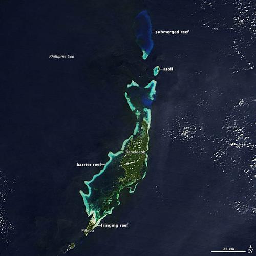
 Palau Satellite PhotoPhoto: Public Domain
Palau or Belau (officially: Republic of Palau and in Palau: Beluu er a Belau) is an island republic in the North Pacific, 800 km west of the Philippines. The total land area of the 343 large and small islands is 487 km2. The capital of Palau is Koror on the island of the same name. Together with the Federation of Micronesia, Palau forms the archipelago of the Caroline Islands. Palau belongs to the continent of Oceania.
Landscape
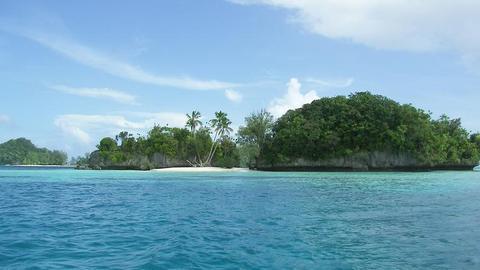
The republic comprises some 25 mostly uninhabited coral islands, of which the densely forested Babeldaob (Babalthuap approx. 370 km2) is the largest. Other large islands are Koror, Peleliu and Angaur. Palau also consists of the coral atolls Kayangel and Ngeruangel and around 200 limestone islands known as Rock Islands. There are also six isolated islands: the Sonsorol Islands, Pulo Anna, Merir, Tobi and Helen, together forming the Southwest Islands. The highest point in Palau is Babeldaob Island (217 metres). The Palau Islands are named after their discoverer, the British Captain Pelew.
 Uninhabited rocky islets, PalauPhoto: Peter R. Binder in the public domain
Koror Island
- Koror Island is the economic centre of Palau and Koror is the capital.
- The total number of residents is about 12,300, which is about two-thirds of Palau's total population.
- Koror consists of the main island and the uninhabited islands of Malakal and Arakabesang connected by an elevated road.
Rock Islands
- 200 limestone islands with jungle vegetation.
- Some islands have caves with stalactites and underground channels.
- There are about 80 salt lakes on the islands.
- Most islands wear out at the bottom.
Babeldaob (Babelthuap)
- The total number of residents is about 4000.
- Babeldaob consists of ten provinces.
- It is a volcanic island and the highest point is Mount Ngerchelchuus (217 metres).
- There is a large natural freshwater lake, Ngardok Lake, which is 914 metres long and 3.6 metres deep.
- Beautiful sandy beaches in the east.
- Ngarchelong in the north has 37 basalt monoliths weighing up to 5000 kg.
Peleliu
- The total number of residents is about 575.
- The total land area is about 13 km2.
- One of the bloodiest battles of the Second World War was fought here (approx. 15,000 dead in two months).
Angaur Island
- The total number of residents is about 200.
- Located outside the reef that surrounds most of Palau's islands.
- Kayangel Atol
- Four islands with white sandy beaches.
- Approximately 137 people in 41 houses.
- One needs special permission to stay there.
- Kayangel has two "chiefs", one for the north and one for the south!
South-West Islands
- Six islands, Sonsorol, Fana, Pulo Anna, Merir, Tobi and Helen, all no larger than 2.5 km2
- Indigenous languages are Sonsoroese and Tobian.
- Together less than 100 residents.
Sources
Galbraith, K. / Micronesia
Lonely Planet
Levy, N.M. / Micronesia handbook Moon
CIA - World Factbook
BBC - Country Profiles
Copyright: Team The World of Info