GERMANY
Geography and Landscape

Geography and Landscape
| Basic information | |
| Official language | German |
| Capital | Berlin |
| Area | 357.022 km² |
| Population | 82,229,585 (2021) |
| Currency | euro (EUR) |
| Web | .de |
| Code. | DEU |
| Tel. | +49 |
Cities in GERMANY
| Berlin | Cologne | Dortmund |
| Frankfurt | Hamburg | Heidelberg |
Popular destinations GERMANY
| Bavaria |
Geography and Landscape
Geography
Germany (German: Deutschland), officially: Federal Republic of Germany (German: Bundesrepublik Deutschland; abbreviated: BRD), is a federal republic in Central Europe.
The total area has been 356,970 km2 since German reunification on 3 October 1990, making Germany the sixth largest country in Europe after Russia, Ukraine, France, Spain and Sweden. Germany is centrally located on the European continent and borders no fewer than nine countries: Denmark (68 km) in the north, the Netherlands (577 km), Belgium (167 km), Luxembourg (135 km) and France (451 km) in the west , Switzerland (334 km) and Austria (784 km) in the south, and the Czech Republic (646 km) and Poland (456 km) in the east. About one third of the current German territory is formed by the former Deutsche Demokratieve Republik (DDR).
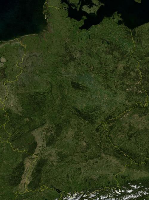
Germany stretches geographically from the Wadden island of Sylt in the north to Oberstdorf in southern Bavaria, and from Görlitz in the east on the Polish border to the far west of North Rhine-Westphalia. The longest distance from north to south is 876 km and from west to east 640 km. The borders of Germany have a combined length of 3618 kilometers.
Large islands include Rügen (930 km2), Usedom (German section 373 km2), Fehmarn (185 km2), Sylt (99 km2), Borkum and Norderney.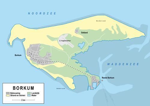 Wadden Island Borkum, GermanyPhoto: TwanRebel CC 4.0 International no changes made
Landscape
Germany consists of three major geographic landscapes: from the north, the landscape gradually changes from flat lowlands through low mountains to the high mountains of the Alps.
The North German lowland is part of the Eastern European lowland, which stretches from the Baltic states, along the coasts of Poland and Germany to the northern provinces of the Netherlands.
The generally fertile North German lowland landscape (0-200 meters) was formed in the ice ages of the Pleistocene, has a gently undulating bottom and here and there completely flat. The northernmost elevation, south of the Baltic Sea, is called the Baltic land ridge and is rich in lakes and forests. The second elevation lies further south from the Lower Elbe to the Katzengebirge. Parallel to these areas is a gently undulating, loamy area to the north and a wide strip of sterile sandy soil in the south, partly covered with heather (such as the Lüneburg Heath). In the same north-south direction there are several primeval stream valleys, 20 kilometers wide, previously consisting of peat, which are a result of the Ice Age. These used to be the river beds that drained the melt water from the ice sheet. They are now only visible as slightly lower lying strips in the landscape. More to the south, the North German Plain enters the low mountain ranges with deep curves, including the Middle Rhine Plain and the Saxon Plain.
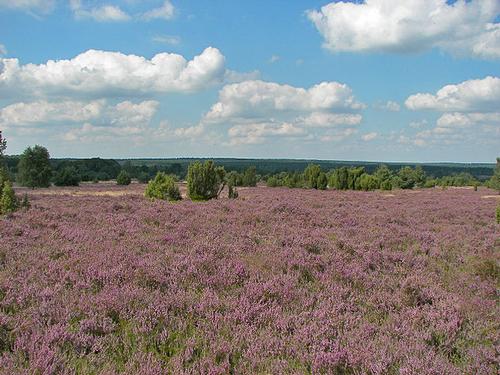 Typical landscape Lüneburg Heath, Northern GermanyPhoto: Willow CC 3.0 Unported no changes made
The German low mountain range (200-1500 meters) forms a natural division between the north and the south of the Federal Republic and is geologically a very complicated area. In the west, the mountainous region begins with a number of chains that are intersected almost at right angles by the Rhine: Rhines Schisteengebirge, Eifel, Westerwald (up to 657 m high), changing into Rothaargebirge, Hunsrück and Taunus (highest point: Grosse Feldberg 881 m ), to which connect the Vogelsberg (highest point: Taufstein 772 m) and the Rhör Mountains (up to 950 m high).
Further north is the Harz (highest point: Brocken 1142 m), with to the west the Weser Bergland and the Teutoburg Forest (highest point: Völmerstod 408 m) and to the north-east the Fläming. To the east of the Rhön is the Thuringian Forest (highest point: Grosser Beerberg 982 m) and to the southeast of it, the Fichtel Mountains form a junction with the Ore Mountains to the northeast, the Upper Palatinate-Bohemian Forest to the southeast and the Fränkische Alb to the southwest. The Franconian Alb is geologically integrated with the Swabian Alb and both are bounded to the south by the Danube.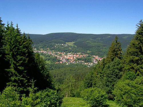 Grosser Beerberg, highest mountain of the Thuringian ForestPhoto: Elop CC 2.5 Generic no changes made
Rivers have cut deep valleys in mountain ranges throughout the low mountain range. The Rhine has already been mentioned above and the Main, the Moselle and the Neckar can also be mentioned. Most of the villages and towns have been built in these river valleys and the slopes are very suitable for wine growing.
The Alps are a younger mountain range than the low mountain ranges in Germany. This makes the tops of the Alps more pointed than those of e.g. the Black Forest or the Erz Mountains.
South of the Danube, the low mountain range slowly changes into the Alps. The land there gradually rises and changes into the moraine region of the Pre-Alps, with an average height of 500 meters, a wooded area with both hills and many lakes. In the extreme south lies the relatively small German part of the Alps, which also forms the border with Austria, the so-called Limestone Alps.
From west to east lie the Allgäu Alps (highest point: Nebelhorn 2224 meters), the Ammergauer Mountains, the Berchtesgadener Alps (highest point: Watzmann 2713 meters) and the steep Wetterstein Mountains with the Zugspitze as highest point in Germany (2962 meters). Zugspitze, highest mountain of GermanyPhoto: Octagon CC 3.0 Unported no changes made
Highest mountains in Germany:
Zugspitze 2962 meter (Wettersteingebirge)
Hochwanner 2746 meter (Wettersteingebirge)
Höllentalspitze 2745 meter (Wettersteingebirge)
Watzmann 2713 meter (Berchtesgadener Alpen)
Plattspitze 2679 meter (Wettersteingebirge)
Hochfrottspitze 2649 meter (Allgäuer Alpen)
Mädelegabel 2645 meter (Allgäuer Alpen)
Dreitorspitze 2633 meter (Wettersteingebirge)
Alpspitze 2628 meter (Wettersteingebirge)
Hochkalter 2607 meter (Berchtesgadener Alpen)
Rivers, canals and lakes
Germany has several independent river systems that flow from south to north, the main ones being the Elbe (1112 kilometers; 700 kilometers in Germany), the Weser and the Rhine (865 kilometers in Germany). These rivers flow to the North Sea, the Danube (2842 km of which 686 km in Germany) flows into the Black Sea. The Weser (440 km) is the only one of the mentioned rivers that flows entirely through German territory.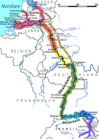 Rhine basin, GermanyPhoto: Ulamm CCC 3.0 Unported no changes made
Other important rivers are the Oder, with its tributary the Neisse, the Ems, the Isar, the Neckar, the Ruhr, the Spree (382 km), the Lahn and Moselle and the Main (524 km), tributaries of the Rhine.
Other important rivers are the Oder, with its tributaries the Neisse, the Ems, the Isar, the Neckar, the Ruhr, the Spree (382 km), the Lahn and the Moselle and the Main (524 km), tributaries of the Rhine.
| Longest rivers in Germany: | ||
| length | of which navigable | |
| Rhine | 865 km | 778 km |
| Elbe | 700 km | 700 km |
| Danube | 647 km | 387 km |
| Main | 524 km | 384 km |
| Weser | 440 km | 440 km |
| Ems | 371 km | 238 km |
| Neckar | 367 km | 201 km |
| Havel | 343 km | 243 km |
| Mosel | 242 km | 242 km |
| Elde | 208 km | 180 km |
| Oder | 162 km | 162 km |
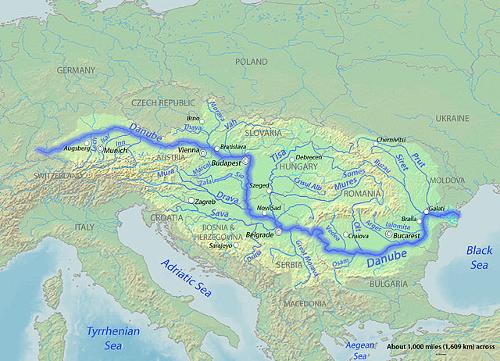 Danube River BasinPhoto: Shannon CC 4.0 International no changes made
Almost all rivers are normalized and are interconnected by channels running from west to east. The important channels for shipping are: the Mittelland Canal (321 km), the Dortmund – Ems Canal (269 km), the Nord – Ostsee Canal, the Oder – Spree Canal, the Ems – Jade Canal, the Oder– Havel-Kanal, the Küstenkanal, the Elbe-Lübeck-Kanal, the Wesel-Datteln-Kanal, the Elbe-Havel-Kanal and the Rhein-Herne-Kanal. The Main-Donau-Kanal was opened in 1999 (153 km).
Especially in the Alpine foreland (old glacier beds) and the Mecklenburg Lake District there are lakes. The largest lakes are the Müritzsee (after Lake Constance the largest lake in Germany with 110 km2) in Mecklenburg-Vorpommern, the Chiemsee (the largest lake in Bavaria: surface 80 km2), the Schweriner See, the Starnberger See, the Würmsee, the Ammersee and of course the largest lake in Germany, Lake Constance at the Austria / Swiss border. This lake is up to 15 kilometers wide and 74 kilometers long and the total area is 571.5 km². It is located at an altitude of 395 meters and the deepest point is at 252 meters. Most of the lakes are located in the north of Germany, especially in Mecklenburg.
Largest lakes in Germany:
Lake Constanz 571,5 km2
Müritz 110,3 km2
Chiemsee 79,9 km2
Schwerinersee 60,6 km2
Starnbergersee 56,4 km2
Ammersee 46,6 km2
Plauer See 38,0 km2
Kummerower See 32,2 km2
Steinhuder Meer 29,1 km2
Grosser Plöner See 29,0 km2
Schaalsee 23,3 km2
Selentersee 22,4 km2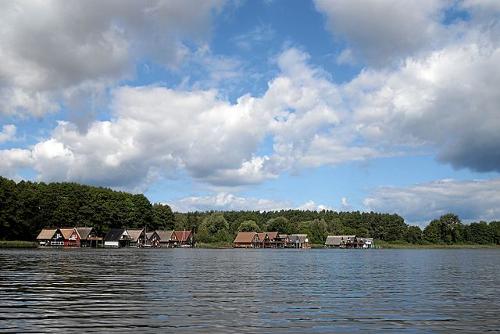 Lake Müritz, GermanyPhoto: Mboesch CC 4.0 International no changes made
Coast
In the northwest, the North Sea coast with the East Frisian islands is a continuation of the Dutch Wadden area. The actual North Sea coast is articulated: the tidal current penetrates far into the estuaries and has eroded them in a funnel-shaped way, so that the ports of Bremen and Hamburg, among others, are 70 and 100 kilometers inland respectively. The North Sea coast is a flat area with canals, dikes and islands. The island of Sylt off the coast of Schleswig-Holstein is connected to the mainland by a bridge.
The Baltic Sea coast is articulated in the west with fjords and sandy arches, in the east, on the other hand, flat: there are also beach lakes here. Steep coasts are almost non-existent but can be found on the islands of Rügen (122 meter high chalk cliffs), Heligoland (with towering red rocks) and Samland.
East Frisian Islands
Borkum 30,7 km²
Norderney 26,3 km²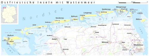 Map East Frisian islands, GermanyPhoto: Maximilian Dörrbecker (Chumwa)CC 2.0 no changes made
North Frisian Islands
Sylt 99,2 km²
Föhr 82,9 km²
Nordstrand 50,4 km²
Pellworm 37,4 km²
Amrum 20,4 km²
Schleswig-Holstein Islands
Fehmarn 185,4 km²
Mecklenburg Islands
Poel 34,3 km²
Vorpommern Islands
Rügen 930,0 km²
Usedom 373,0 km² (German part; in total 445 km²)
Sources
Ayer, E.H. / Germany
Lucent Books
Egert-Romanowska, J. / Duitsland
Van Reemst
Europese Unie : vijftien landendocumentaties
Europees Platform voor het Nederlandse Onderwijs
Mark, D.F.W. van der / De Bondsrepubliek Duitsland voor en na 1990 : geschiedenis, politiek, economie en ruimtelijke ontwikkeling
Landensurveys
Tatsachen über Deutschland
CIA - World Factbook
BBC - Country Profiles
Copyright: Team The World of Info