MONTENEGRO
Geography and Landscape

Geography and Landscape
| Basic information | |
| Official language | Montenegrin |
| Capital | Podgorica |
| Area | 14.026 km² |
| Population | 628,202 (2021) |
| Currency | euro (EUR) |
| Web | .me |
| Code. | MNE |
| Tel. | +382 |

Cities in MONTENEGRO
| Podgorica |
Geography and Landscape
Geography
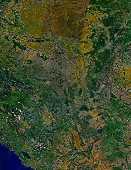
The Republic of Montenegro (Serbo-Croatian: Republican Crne Gora: short form Crne Gora = black mountains) is part of the Balkans in south-eastern Europe. The country has a surface area of 13,812 km2.

Montenegro borders the Adriatic Sea to the southwest (293.5 km, of which 73 km is beach), Croatia to the west (14 km), Bosnia and Herzegovina to the northwest (225 km), Serbia to the northeast (203 km) and Albania to the southeast (172 km). The total length of the Montenegrin borders is approximately 614 km.
Landscape
The landscape of Serbia and Montenegro is very varied but in general it is a distinctly mountainous country. 60.5% of its territory lies above 1000 metres.
In the north there are gently rolling fertile plains; in the east and south-east mountain ranges and in the south-west very high coastlines; the Boka Kotorska is even called the southernmost "fjord" of Europe.
The narrow coastal plain consists of sand and pebble beaches, bays, but also the Boka Kotorska is located here, also called "the southernmost fjord in Europe". To the south, the coast is divided into the so-called "Rivieras":
The Kotor Riviera has several types of beaches and is covered with Mediterranean vegetation. The Tivat Riviera has a total of seventeen beaches and three islands off the coast, including the flower island of St. Marko and the Lady of Mercy island. The Budva Riviera has many coves with the best sandy beaches of Montenegro, surrounded by high cliffs. The Ulcinj Riviera ends at the mouth of the Bojona River, which flows into the Adriatic Sea. This part of the coast has 18 coves, but also two peninsulas, Marjan and Mandra with a lot of subtropical vegetation.
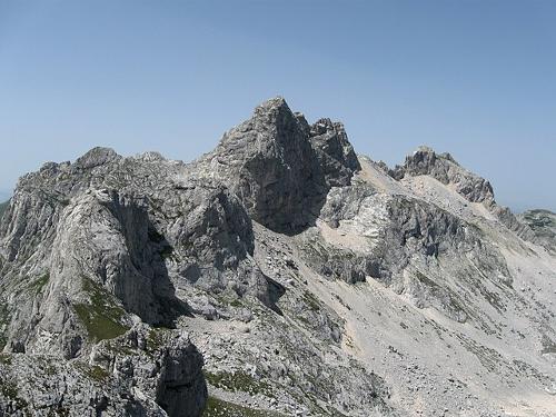
In the north of Montenegro there is a large karst mountain range, the Durmitor massif (also a National Park), with the highest peak entirely in Montenegro, the 2522 m high Bobotov kuk. The average height of the Durmitor massif is 1400 m and the area has more than 48 peaks above 2000 m. Other high mountains in Durmitor National Park are Savin kuk (2313 m), Crevena kuk (2175 m), Meded (2287 m) and Planinica (2330 m). In winter Durmitor is the only real ski resort of Montenegro with the central ski resort Zabljak (1465 m), the highest city of the Balkans.
 Bobotov Kuk, highest mountain in MontenegroPhoto:Goran.Smith2 CC 3.0 Unportedno changes made
The deepest ravine in Durmitor National Park, also the deepest in Europe and the second deepest in the world, is the Tara ravine (1300 m deep) and the river with that name is the longest in Montenegro. Furthermore, there are eighteen glacial lakes and 748 springs from which pure mountain water flows.
The central inland of Montenegro consists of a karst plateau of an average height of 1000 m, with summits up to 1900 m, like the Orjen (1894 m) and the Lovcen (1749 m). The 5400 hectare Biogradska Gora National Park is an isolated area in Montenegro, eighty percent of which consists of medieval forests. The area was declared a national park as early as 1878, but six years later than the world's first national park, Yellowstone Park in the United States. The park is known not only for its 60-metre-high ancient trees, but also for its five glacial lakes, known as the "mountain eyes" (including Biogradsko, Pešica, Ursulovacka and Šiško).
Montenegro has 40 lakes, including the largest lake in the Republic and the Balkans, Lake Skadar (391 km2; 43 km long, 14 km wide and an average depth of 7 m). Approximately 219 km2 belong to the territory of Montenegro, the rest to Albania.
There are fourteen islands off the coast of Montenegro with a total coastline of 15.6 km.
The rivers of Montenegro flow into the Black Sea (including Piva, Tara, Ibar, Lim and Cehotina) and the Adriatic Sea (including Moraca, Zeta and Bojana). The longest rivers are the Tara (141 km), the Lim (123 km), the Cehotina (100 km), the Moraca (99 km), the Piva (78 km), the Zeta (65 km) and the Bojana (30 km).
Although Montenegro is located in an area where earthquakes occur regularly, the country is rarely hit by a catastrophic earthquake. The last major earthquake, measuring 7.1 on the Richter Scale, occurred on Sunday, 15 April 1979. It killed 94 people and injured about 1,000. More than 80,000 people were made homeless.
Sources
Detrez, R. / Servië-Montenegro : mensen, politiek, economie, cultuur, milieu
Koninklijk Instituut voor de Tropen ; Novib
Montenegro
Naklada Ljevak
Rellie, A. / Montenegro
Bradt Travel Guides
Schuman, M.A. / Serbia and Montenegro
Facts On File
CIA - World Factbook
BBC - Country Profiles
Copyright: Team The World of Info