WALES
Geography and Landscape
Geography and Landscape
| Basic information | |
| Official language | Welsh, English |
| Capital | Cardiff (Caerdydd) |
| Area | 20.761 km² |
| Population | ca. 3,170,000 (2020) |
| Currency | pound sterling (GBP) |
| Web | .uk |
| Code. | GBR |
| Tel. | +44 |
Cities in WALES
| Cardiff |
Popular destinations UNITED KINGDOM
| England | Northern ireland | Scotland |
| Wales |
Geography and Landscape
Geography
Wales (Welsh: Cymru, Land of brotherhood) is the westernmost part of the island of Great Britain. Formerly a principality, Wales is part of the United Kingdom of Great Britain (Wales, England and Scotland) and Northern Ireland.
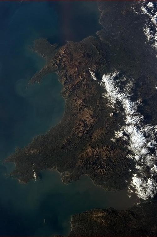
The total area of Wales is 20,768 km2. Wales measures a maximum of 200 kilometers from north to south and between 180 and 60 kilometers from east to west. The very jagged coastline amounts to a total of 1,232 kilometers, of which two thirds enjoy special protection as a 'Heritage Coast'.
Wales is surrounded on three sides by waters, to the north by the Irish Sea, to the south by the Bristol Channel and to the west by St. George's Channel and Cardigan Bay. For more than a thousand years, England has been separating the Offa's Dyke, a north-south boundary wall, 269 kilometers long from Wales from the "motherland". Wales borders four English counties here: Cheshire, Shropshire, Hereford & Worcester and Gloucestershire.
Wales also includes the artificial peninsula of Anglesey, which is connected to the mainland by the Menai Bridge.
Landscape
North Wales
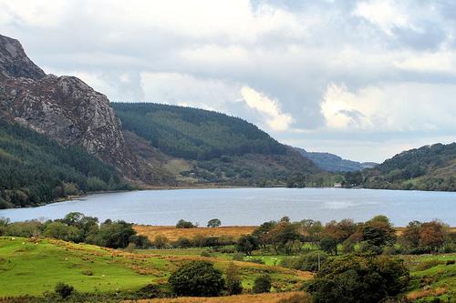 Snodonia National Park WalesPhoto: Tim Felce CC 2.0 Generic no changes made
Most of North Wales is occupied by the rugged mountains of Snowdonia, which has been declared a national park (214,159 ha) since 1951. This park is also home to the highest peak in Wales and England, Mount Snowdon (Welsh: Yr Wyddfa Fawr and 1085 meters high).
The surrounding mountains usually do not get much higher than 900 meters, including the Cader Idris (892 m). The Cader Idris connects the gently rolling hills of Mid Wales with the alpine mountains of the north. Many peaks can be climbed from Ogwen in the north: the Tryfan (917 m), the Glyder Fach (995 m), the Glyder Fawr (999 m) and only peaks of the Carneddau Range, such as the Carnedd Dafydd (1044 m) and the Carnedd Llewelyn (1062 m).
Several large valleys run from the Snowdon massif towards the sea. Several rivers have created wide valleys or deltas during the Ice Age, such as the Dwynyd, the Glaslyn, the Conwy, the Mawddach, the Dysynni and the Dovey. In the vicinity of Nant Gwynant, Llanberis and Tal-y-llyn there are some mountain lakes in the valleys. Snowdonia also has a very varied landscape with open heath plateaus, mountain meadows, rugged ridges, narrow valleys and valleys.
The flat Isle of Anglesey and the undulating Llyn Peninsula are known for their beautiful, highly articulated coasts.
Mid Wales
The almost uninhabited Mid Wales is mainly green and hilly. This area contains the Cambrian Mountains, a mountain range running from north to south with fairly steep slopes, deep, elongated valleys and partly wooded, partly heather and grass covered plateaus.
The Cambrian Mountains extend to the southern foothills of Snowdonia and stretch from Caernarfon in the north to Carmarthen near Swansea in the southwest. The highest peak in the Cambrian Mountains is the Aran Fawddwy at 905 meters.
South Wales
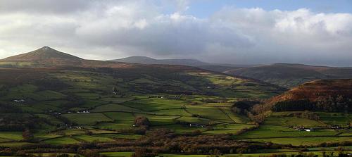 Brecon Beacons National Park WalesPhoto: Simon Powell CC 3.0 Unported no changes made
The landscape of the southeastern "Valleys" has been seriously affected by coal mining and the construction of iron and steel factories. The most famous valleys are Vale of Neath, Dulais Valley, the Rhondda Valleys (Rhondda Fawr, large Rhondda and Rhondda Fach, small Rhondda), Taff and Cynon Valleys, Rhymney Valley, Sirhowey Valley and Ebbw Valley.
The rest of South Wales is still beautiful in terms of natural beauty, including the rugged, mountainous Brecon Beacons National Park (135,144 ha). This area is characterized by a number of almost treeless ridges, interrupted by elongated river valleys running from north to south. The Black Mountains (highest peak: Waun Fach with 811 meters), the Brecon Beacons (highest peak: Pen y Fan with 886 meters) and the Fforest Fwar (highest peak Fan Gihirlich with 726 meters) run from east to west. In this area is also the Black Mountain (Welsh: Mynydd Du with an altitude of 802 m).
In the southwest is the Pembrokeshire Coast National Park with its magnificent rocky coast. Rugged rocks, bird islands, wide bays, beaches and small inlets alternate here. Furthermore, the area is quite flat with an agricultural tinted interior.
The Gower Peninsula in the far south of Wales is one of the five Areas of Outstanding Natural Beauty. The area has a varied landscape with inland a wavy landscape with alternating meadows and fields, heather and grass (high) plains, forests and deep river valleys. To the north, Gower is bordered by salt marshes, such as the flat Llanrhidian Sands and Marsh, parts of the broad estuary of the Loughor.
The uninhabited west coast is almost entirely taken up by the beach of Rhossili Bay, which is sheltered by the rock walls with the cliffs of Burry Holms and the headland of Worms Head on either side. The south coast is a series of jagged rock formations, bays and sometimes beautiful snow-white beaches. Separated from Cefn Bryn, a red sandstone hill chain, salt marshes extend to the north. Just off the coast is the treeless, volcanic Skomer Island, a bird paradise.
Rivers, lakes and canals
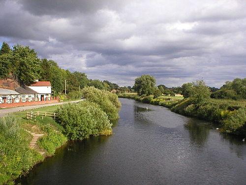 River Dee runs between Holt and Farndon across the Welsh border with EnglandPhoto: Richard Siessor CC 2.0 Generic mo changes made
Wales has many rivers, streams and lakes. The longest rivers are the Dee, Severn and Wye which flow through the lowlands along the English border. In fact, the Severn is one of the longest rivers in Wales and England combined. The River Dee originates in Lake Bala and flows through North Wales across the border with England to the Irish Sea; to the south, the Usk, Wye, Taff, Tawe and Tywi flow through deep valleys to the Bristol Channel. The largest natural lake in Wales is Bala Lake (Welsh: Llyn Tegid) in North Wales and is over 6 kilometers long. Llangorse Lake is the largest natural lake in the south. Well-known lakes are Llyn Gwynant, Llyn y Fan Fach, Llyn y Fan Fawr and the Cregennen Lakes. Wales also has many icy mountain lakes, about 250 in Snowdonia alone.
Most of the Welsh lakes are artificial and serve as a water reservoir (Llyn Brianne and Lake Vyrnwy). The "Mid Wales Lake District" consists of five water reservoirs. Four of these were built for the city of Birmingham between 1892 and 1903, nearly 120 kilometers to the east; the fifth dates from 1952, so that the total capacity of the 14 km long lakes totaled over 100 million liters of water.
In order to connect the rivers, ports and factories of mainly Swansea, Cardiff and Chester with the inland industry, many channels were dug for freight transport in the 18th and 19th centuries. These channels are now actually only used for recreation and water sports.
Sources
Beeftink, A. / Zuid-Engeland en Wales
Van Reemst
Berkien, G. / Wales
Kosmos-Z&K
Berkien, G. / Wales
Kosmos-Z&K
Danse, W. / Midden-Engeland en Wales
ANWB
Fröhlich, D. / Wales
Deltas
Hendriksen, B. / Wales
Van Reemst
Hestler, A. / Wales
Marshall Cavendish
King, J. / Wales
Lonely Planet
Westphal, U. / Wales
Van Reemst
CIA - World Factbook
BBC - Country Profiles
Last updated January 2026Copyright: Team The World of Info