NETHERLANDS

Cities in NETHERLANDS
| Amsterdam | Eindhoven | Maastricht |
| Rotterdam | The hague |
Geography and Landscape
Geography
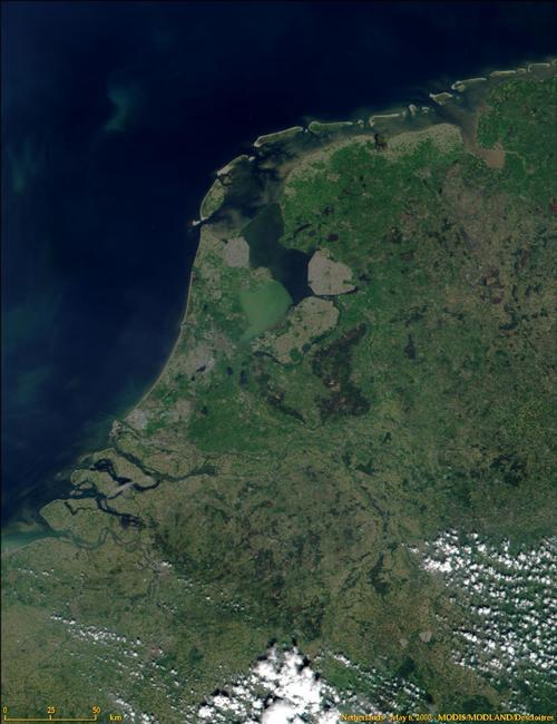
The Netherlands (French: Pays-Bas; German: Die Niederlande; English: The Netherlands; abroad, the Netherlands is often called Holland) is the part of the Kingdom of the Netherlands located in Western Europe. The total area of the Netherlands is 41,543 km². The Netherlands is about 300 kilometers long from north to south and about 200 kilometers wide from east to west. The Netherlands is slightly larger than Belgium and nine times smaller than Germany.

As enclaves within the province of Noord-Brabant there are approximately 30 small Belgian areas, which together form the municipality of Baarle-Hertog; within it are two Dutch exclaves, belonging to the municipality of Baarle-Nassau. In addition to the mainland, the Netherlands includes the Wadden Islands: Texel, Vlieland, Terschelling, Ameland, Schiermonnikoog and Rottumeroog.
The Netherlands borders Germany to the east (577 km), Belgium to the south (450 km), the North Sea to the west and the North Sea and the Wadden Sea to the north (the total coastline is 451 km).
The Netherlands Antilles are an autonomous part of the Kingdom of the Netherlands and comprise two island groups in the Caribbean that are part of the Lesser Antilles, together 800 km2 and with approximately 200,000 inhabitants. The two archipelago belong to the Leeward and Windward Islands respectively and are approximately 900 km from each other; the first group comprises the islands of Bonaire (with Klein-Bonaire) and Curacao, which are located off the coast of Western Venezuela; the second group comprises the islands of Saba, Sint Eustatius and Sint Maarten, located to the east of Puerto Rico.
Until January 1, 1986, when it was granted separate status, the Leeward Island of Aruba was also part of the Netherlands Antilles.
Landscape
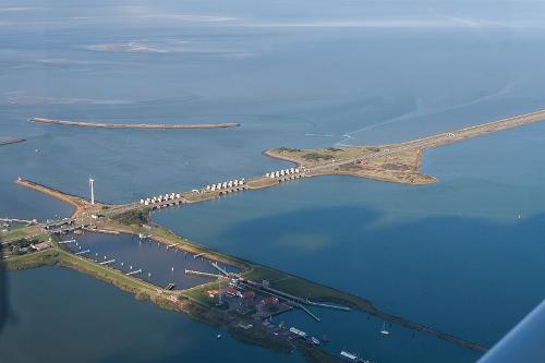
 Afsluitdijk NetherlandsPhoto: MD van Leeuwen CC 3.0 Unported no changes made
Despite the small size of the Netherlands, there is a wide variety of landscapes, which, however, are often created by human intervention.
The Dutch landscape is therefore strongly determined by dyke construction, land reclamation, draining marshes, agriculture and the construction of cities and roads.
The Netherlands hardly knows any real primeval natural landscapes anymore and nature is dominated by fields, meadows and heaths that were created by the massive clearing of forests. The forests that now occur in the Netherlands have all been planted.
Approx. 200,000 years ago, the Netherlands was partly covered by land ice. Gravel, sand, boulder clay and boulders were deposited up to the Haarlem-Nijmegen line, and sand and gravel were pushed aside by the glacier tongues and parallel, up to 100 meters high, ridges were formed in Overijssel, Gelderland and Utrecht. This hilly area is largely covered with moors and forests.
The soil south of the major rivers consists mainly of sand and gravel. The soils in South Limburg are more than a million years old and not covered by younger deposits. Minerals such as marl and coal are found here.
Peat areas were formed in some swampy areas of the High Netherlands, which, however, were drained and reclaimed. After the construction of many canals, the peat was excavated, then removed and used as fuel, for example in the form of peat.
The Lower Netherlands also has peat areas and especially in the Dutch-Utrecht peat area a lot of peat was excavated and puddles were created that are now used as recreation areas, e.g. the Loosdrechtse plassen above Utrecht. The low moor areas arose behind a closed row of dunes.
The following landscape types can be distinguished on the basis of the height and soil differences:
The plateau of South Limburg.
The ground moraine landscape of Drenthe and eastern Friesland.
The moraines area in mainly Gelderland and Overijssel.
Rows of hills in Utrecht (including Utrecht hills), Overijssel and Gelderland (including Veluwe).
The cover sand areas of North Brabant and North and Central Limburg.
The raised moor areas in Groningen, Drenthe and the Kop van Overijssel.
The Dutch-Utrecht and Frisian-Overijssel peat areas.
The areas with young sea clay in Friesland, Groningen, northern North Holland and Zeeland.
The river clay areas in the middle of the country around the Maas and the Rhine.
The dune areas along the coast of North and South Holland.
Well-known regions and landscapes are further:
The Achterhoek, the Betuwe, Twente, the Gooi, the Peel, West Friesland, the Zaanstreek, Salland, the Ommelanden, the Biesbosch, the Kennemerland and the Hondsrug.
Land reclamation has created a lot of new land, including the province of Flevoland, which consists of the Noordoostpolde and Eastern and Southern Flevoland sea polders, mainly used as a residential, work and recreation area with growth cities such as Lelystad and especially Almere.
The Wieringermeer and the Noordoostpolder are typically agricultural polders. Together, a land acquisition of approximately 1650 km2 has been booked. The Afsluitdijk, a dam of about 30 kilometers between North Holland and Friesland, turned the Zuiderzee into a lake, the IJsselmeer.
The Wadden Islands are located north of the IJsselmeer. Texel is the largest Wadden Island with an area of approximately 216 km2.
To the southeast, the polder landscape disappears and a heather landscape with forests, sand dunes and grass plains appears. Here you will find the nature reserve "De Hoge Veluwe", a national park with an area of 5,400 ha.
The eternal battle against the water is clearly reflected in the landscape. A large part of the Netherlands lies below sea level and is protected by dikes against the advancing North Sea. The Delta Works in the province of Zeeland are also known. The polders in this area are protected against flooding by a dam system. More than 1,800 people lost their lives in the last major flood in 1953.
The height in the Netherlands is measured from 0 meters Normal Amsterdam Level (NAP), which corresponds to the average high tide level along the coast. The border between the Low Netherlands and the High Netherlands is 1 meter above NAP.
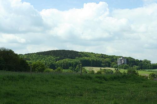
In most of the Netherlands, the soil consists of material brought in by the sea, rivers or wind. The Netherlands was covered with pack ice for a long time and then the ridges in Utrecht, Overijssel and Gelderland were formed in the form of moraines. In the south of the province of Limburg, the landscape has been strongly influenced by erosion, although an overburden of fertile loess has obscured the erosion character. South Limburg is also the most hilly part of the Netherlands and here is the highest point in the Netherlands, the Vaalserberg with 322.7 meters.
 Vaalserberg, highest hill in the NetherlandsPhoto: Xamos, CC BY-SA 3.0 no changes made
The image of the Dutch landscape was strongly determined in the Holocene by the activity of the rivers and the sea. Vast clay areas were formed by the sea and beach walls and with the decomposition of the peat area, formed behind these beach walls, the Zuiderzee and the Biesbosch were created. The wind created the dunes and sand drifts in the Holocene.
The landscape is also strongly determined by human activities. Deep reclamation and subsequent reclamation of lakes and ponds have created deep reclaimed land (the lowest point in the Netherlands is in the municipality of Nieuwerkerk aan den IJssel and is 6.74 m below NAP).
Approx. 24% of the Netherlands is below sea level. The rest of the country is at sea level or slightly above. Much of the Netherlands is protected from seawater by dikes that are sometimes more than 25 meters high.
Rivers, lakes and ponds

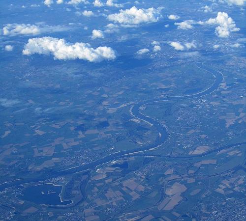
Rhine River at Nijmegen in the NetherlandsPhoto:Scorewith German CC 3.0 Unported no changes made
The Rhine is both a glacier river and a rain river and the discharge of the Rhine amounts to an average of 69 billion m3 of water per year. The canalisation of the Neder-Rijn and the Lek improved the navigability of the IJssel, the Pannerdens Canal, the Neder-Rijn and the Lek.
The Maas is a real rain river, which means that the difference between the largest and the smallest occurrence of discharge is much greater than that at the Rhine. Much of the Maas has been canalised.
Only the wide mouth of the Scheldt lies within the Dutch borders. The small rivers that originate outside Dutch territory only transport an average of 3 billion m3 of water per year across the borders. This quantity is only of regional significance in the context of water management.
The many lakes and ponds are mainly located in the peat landscape of the Netherlands and have often arisen naturally by erosion of peat banks after, for example, a break-in by the sea led to the formation of open water.
Many lakes are formed from old rivers in the peat landscape. The fertilized areas are often referred to as puddles. A large number of lakes and ponds have been drained over centuries. The lakes, which were created as a result of the Zuiderzee Works (IJsselmeer and its Randmeren) and the lakes formed by the Delta Works, occupy a special place.
Sources
Haafkens, M. / Nederland
Gottmer
Harmans, G.L.M. / Nederland
Van Reemst
Metze, M. / De staat van Nederland
SUN
Ver Berkmoes, R. / Netherlands
Lonely Planet
CIA - World Factbook
BBC - Country Profiles
Last updated January 2026Copyright: Team The World of Info