MEXICO
Climate and Weather

Climate and Weather

Cities in MEXICO
| Mexico city | Playa del carmen | Riviera maya |
Climate and Weather
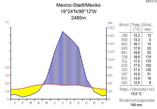
Climatically, Mexico can be divided into the east coast, the west coast and the Central Plateau. The climate is also strongly dependent on the altitude at which one is located. Taking the above into account, Mexico has roughly two seasons, the dry season in winter, from October to May, and the rainy season in summer, which lasts from May to October, peaking in July and August. Only in the extreme northwest, around Tijuana has a Mediterranean climate with a lot of rain in the winter. Climate diagram Mexico City, Central MexicoPhoto: Hedwig in Washington CC 3.0 no changes made
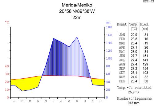
Mexico as a whole can be characterized as arid or semi-arid in that 80% of the country receives less than 800 mm of rainfall. The most arid region of the country is the desert of Altar where it sometimes does not rain for years. The year 1996 was an extremely dry year; the worst drought of the past fifty years was registered. The hurricane season on the east coast starts in June but is most severe in September. Climate diagram, Merida, Eastern-Mexico (Yucatan)Photo: Hedwig in Washington CC 3.0 no changes made
Furthermore, Mexico has three climate zones:
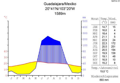
The "tierra caliente", the warm zone, includes all areas below 750 meters. This mainly concerns coastal plains and regions with swamps and tropical rainforests. Places that are located in this climate zone are famous tourist places such as Acapulco, Puerto Vallarta, Veracruz, Cancún and Cozumel. The average annual temperature is between 23 and 26 ° C. In the rainy season the temperatures are much higher than in the dry season and are accompanied by high humidity. In the Yucatán peninsula, daytime temperatures barely drop below 24°C. The temperature differences are also small for the other low plains in the south. In the northern steppes and deserts, the temperature differences are large. In the summer it is scalding hot during the day, but in the winter temperatures regularly drop below freezing point at night. Climate diagram Guadalajara, Western MexicoPhoto: Hedwig in Washington CC 3.0 no changes made
The temperate subtropical areas lie between 750 and 2000 meters and are called the "tierra templada". Average temperatures are between 17and 23° C, but night and day temperatures can be quite different. For example, much of the Mexican plateau lies in this zone and the daytime temperatures have a spring-like character all year round. This is where the main agricultural areas lie.
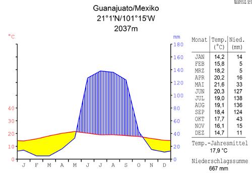
The cold areas, the "tierra fría", lie above 2000 meters. The mountain areas and the higher parts of the Mexican highlands belong to this. Mexico City is located in this zone as it is located at an altitude of 2,240 meters. The average temperature in this zone is below 17°C. The differences can also be great in these areas. Mexico City is quite spring-like in temperature all year round, while high in the mountains it can freeze severely. These areas above 4000 meters where snow and ice predominate are also called "tierra helada". Climate diagram Guanajuato, Central MexicoPhoto: Hedwig in Washington CC 3.0 no changes made
The east coast is exposed to humid winds that bring in air from the Gulf of Mexico, with heavy rains, especially in the south. Only the north coast of Yucatán, in the wind shadow of the peninsula, is relatively dry. The hottest part of Mexico in the summer is the west coast. The Central Plateau also receives little rainfall, especially in the north. The temperatures on the plateau are considerably lower than in the low lying areas with frost during the winter nights. In summer, however, the temperatures here also rise to high values.
Average temperatures at sea level
| City | Lowest | Highest |
| Acapulco | 26,4 | 29,1 |
| Cancún | 25,0 | 29,4 |
| Mazatlán | 20,1 | 28,4 |
| Mérida | 22,9 | 28,0 |
| Puerto Vallarta | 21,0 | 30,0 |
| Veracruz | 21,8 | 28,2 |
Average temperatures at a high level
| City | Lowest | Highest |
| Cuernavaca | 18,7 | 23,5 |
| Guadalajara | 15,2 | 22,8 |
| Mexico-City | 12,6 | 17,9 |
| Oaxaca | 18,7 | 23,6 |
| Puebla | 14,1 | 19,4 |
| Taxco | 19,8 | 25,0 |
Sources
Daling, T. / Mexico : mensen, politiek, economie, cultuur, milieu
Koninklijk Instituut voor de Tropen / Novib
Dunlop, F. / Mexico
Van Reemst,
Mexico
Cambium
Rokebrand, R. / Mexico
Gottmer/Becht
Rummel, J. / Mexico
Chelsea House Publishers
Wagenvoort, E. / Reishandboek Mexico
Elmar
CIA - World Factbook
BBC - Country Profiles
Copyright: Team The World of Info