KIRIBATI
Geography and Landscape

Geography and Landscape
| Basic information | |
| Official language | Kiribatic, English |
| Capital | Tarawa |
| Area | 726 km² |
| Population | 122,516 (2021) |
| Currency | Australian dollar (AUD) |
| Web | .ki |
| Code. | KIR |
| Tel. | +686 |
Geography and Landscape
Geography
Micronesia (from Greek: small islands) consists of about 2300 large and small islands. The islands are scattered in the Western Pacific between Hawaii (at about 6000 km) and the Philippines (at about 2400 km). Geographically, Micronesia consists of four archipelagos: the Marshall Islands, the Mariana Islands, the Gilbert Islands, and the Caroline Islands.
Kiribati, belonging to Micronesia, also includes the Line and Phoenix Islands which are included in Polynesia. The distance from north to south is 2572 km and from east to west 5056 km. This means that the islands are spread over a water area of more than 13 million km2.
Kiribati (officially: Republic of Kiribati; Kiribatic: Ribaberikin Kiribati), is an independent republic within the British Commonwealth and located in the western Pacific. The islands are spread over 3.5 million km2 of ocean. From east to west, Kiribati stretches 3870 km, and from north to south 2050 km. Kiribati includes three island groups and Banaba (5 km2), which is also called Ocean Island. Kiribati belongs to the continent of Oceania.
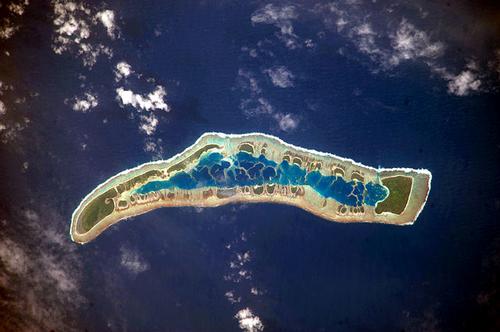
 Millennium Island, KiribatiPhoto: Public domain
Landscape
The total land area of Kiribati is 811 km2. The island groups are: the Gilberts or Tungaru (16 islands), 295 km2; the Phoenix Islands (8), 55 km2 and the Line Islands (including Kiritimati, formerly Christmas Island; 8 of the 11 islands are inhabited), 362 km2. The main island is Tarawa (Gilberts Islands) and the capital is Bairiki.
Except for Banaba, all islands are coral islands that are only 1 to 3 m above the high tide line. The highest point in Kiribati, at 81 metres above sea level, is on Banaba. Banaba is one of the three largest phosphate islands in the Pacific along with Nauru and Makatea in French Polynesia.
Tarawa
- Tarawa is the main island of Kiribati.
- North Tarawa has about 4400 residents; South Tarawa has about 29,000 residents.
- The total land area is about 32.5 km2.
- All government buildings and services can be found in the south.
- The north is very rural.
The Gilbert Islands consist of:
Abaiang
- The number of residents is about 4400 of Butaritari
- The number of residents is about 5000..
- The total land area is about 13.5 km2.
- There is more than 3,000 mm of precipitation per year, making Butaritari the greenest island in Kiribati.
Banaba (Ocean Island)
- The number of residents is about 650.
- The total land area is about 6.5 km2.
- Banaba is the only limestone island in Kiribati.
- The highest point is 78 metres.
- The island was rich in phosphate, but the last time it was mined was in 1979.
Abemama
- The number of residents is about 4000.
- The total land area is about 28 km2.
- The island produces a lot of copra and has rich fishing grounds.
Marakei
- The number of residents is about 3,700.
- The total land area is about 14 km2.
- Anyone visiting the island for the first time is required to travel around the ring-shaped island in a counter-clockwise direction.
- Cigarettes are laid in some holy places to appease the ancestors.
Tabiteuea
- The number of residents is about 6,100.
- It is the residence of the President of Kiribati, Teburoro Tito.
Phoenix Island
Most of the eight Phoenix Islands, all located south of the equator, were added to the Gilbert & Ellice Islands in 1937. Only the island of Kanta is inhabited with about 33 inhabitants. The rest of the islands are uninhabited. The Phoenix Islands are difficult to reach, only by boat.
The westernmost group of islands in Kiribati are the Line Islands. The northern islands of Washington, Fanning and Christmas Island are inhabited. The five islands south of the equator are uninhabited, mainly due to a lack of fresh water. The population of the inhabited islands is growing rapidly, especially the number of people on South Tarawa. Since 1988, residents of South Tarawa may be required to move to other islands (particularly Kiritimati).
Line Islands
The Line Islands cover about 60% of Kiribati's surface area, but the number of inhabitants is only about 7% of the total population. A direct flight from Honolulu to Christmas Island leaves the development of Washington and Fanning far behind. The three inhabited islands all have a different climate: Christmas Island is quite dry, Washington is quite wet and Fanning is just in between.
In 1996, the date line running through Kiribati was moved from the 180th to the 130th meridian, so that the same date applies throughout the country. Kiribati is now the country where a new day begins first. Kiribati was therefore also the first country that could celebrate the millennium, and Caroline Island, which is now called Millennium Island, was the first piece of land that could celebrate the millennium. Unfortunately, Caroline Island is uninhabited.
Fanning (Kiribatic: Tabuaeran, derived from Polynesian)
- The number of residents is about 600.
- The total land area is about 34 km2.
- There are six villages on Fanning.
- Fanning has no natural harbour.
Washington (Kiribatic: Teraina)
- The number of residents is about 600.
- Washington has a freshwater lake, very remarkable for these regions.
- The island is named after US President George Washington.
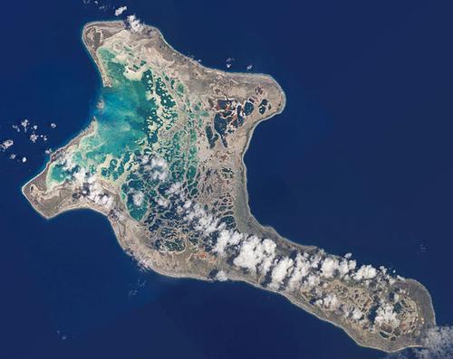
Christmas Island (Kiribati: Kiritimati)
- The number of residents is about 3600.
- The total land area is about 339 km2 (= about 48% of Kiribati's total area).
- Christmas Island was so named by Captain James Cook.
- Weekly charters fly from Honolulu Hawaii to Christmas Island.
- The number of residents tripled in the period 1979-1999.
 Satellite photo of Kiritimati (Christmas Island)Photo: Public domain
Sources
Galbraith, K. / Micronesia
Lonely Planet
Levy, N.M. /Micronesia handbook Moon
CIA - World Factbook
BBC - Country Profiles
Copyright: Team The World of Info