VANUATU

Geography and Landscape
Geography
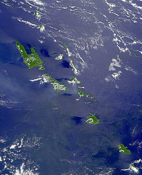
Vanuatu, until 1980 the New Hebrides (officially in Bislama: Ripablik blong Vanuatu; in English: Republic of Vanuatu), is a republic in the Pacific Ocean and is formed by an archipelago of approximately eighty islands. The islands can be divided into three groups: the Torres and Banks islands in the north, Espíritu Santo, Maewo and Efate in the centre and the Tafea islands Tanna, Aniwa, Futuna, Erromango and Aneityumin in the south. Vanuatu is part of Melanesia.
Melanesia is an island world in the Pacific Ocean and part of Oceania, with a total land area of approximately 967,000 km2 and 5 million inhabitants. The area includes New Caledonia and the states of Papua New Guinea, Solomon Islands, Vanuatu and Fiji. The name Melanesia (from Greek melas = black and nesos = island) refers to the skin colour of the inhabitants, who are racially classified as negroids.
Vanuatu is located 170 km south of the Solomon Islands, 230 km north-east of New Caledonia, 800 km west of Fiji and approximately 1900 km north-east of Brisbane, Australia. The total land area covers 12,190 km2 and the total sea area covers about 860,000 km2. The largest islands are Espíritu Santo (4010 km2), Malakula or Mallicolo (2069 km2), Efate or Vaté (980 km2) and Erromanga (900 km2). The twelve largest islands cover 93% of the total land area.

The capital Port Vila is on the island of Efate. Vanuatu rose from the ocean about 22 million years ago after landslides on the ocean floor created a number of mountains. First appeared the islands Santo, Malakula and the Torres group. Then Maewo and Pentecost between 5 and 11 million years ago. The other islands appeared less than five million years ago. It was not until about two million years ago that the islands were slowly pushed upwards and took on their present shapes and sizes. New land is still being added through volcanic activity.
Landscape
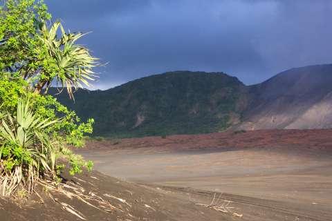
Most of the volcanic rock islands are mountainous or at least covered in steep hills and surrounded by coral reefs. Approximately 35% of the total land area is above 300 metres and 55% of the slopes have an incline of more than 20%. The highest peak in Vanuatu is Mount Tabwemasana on the island of Espíritu Santo at approx. 1811 metres. The islands Ambae, Ambrym and Tanna (including Mount Yasur) have peaks higher than one thousand metres. Some areas are so deeply cut with ravines that they are practically impenetrable. The steep hills are generally densely forested, while the narrow coastal area is dominated by coconut plantations and other agricultural activities.
 Mount Yasur on the island of Tanna, VanuatuPhoto: Bruno.menetrier in the public domain
Vanuatu lies right on top of the "Pacific Ring of Fire". In fact, the islands lie exactly on the edge of the Pacific tectonic plate, which slides over the Indo-Australian plate. Therefore, earthquakes and volcanic eruptions occur frequently. Some areas on Vanuatu are lifted two centimetres a year, while other areas sink. Seismographs record numerous quakes every day, most of which, however, are hardly felt. An earthquake in 1994 with more than seven on the Richter scale caused a lot of damage. Earlier earthquakes in 1875 and 1948 caused tsunamis (tidal wave resulting from a wholly or partially submarine earthquake or landslide), which destroyed entire villages. Vanuatu has nine active volcanoes (two of which are underwater) on the islands of Tanna, Ambrym, Gaua and Lopevi. There are also many active geysers and hot springs. On 10 January 2001, Vanuatu was hit by an earthquake measuring 6.9 on the Richter scale.
Sources
O'Byrne, D. / Vanuatu
Lonely Planet
Stanley, D. / South Pacific Handbook
Moon
CIA - World Factbook
BBC - Country Profiles
Copyright: Team The World of Info