ROMANIA
Geography and Landscape

Geography and Landscape
| Basic information | |
| Official language | Romanian |
| Capital | Bucharest |
| Area | 238.391 km² |
| Population | 19,014,792 (2021) |
| Currency | Romanian leu (RON) |
| Web | .ro |
| Code. | ROU |
| Tel. | +40 |
Cities in ROMANIA
| Brasov | Bucharest |
Geography and Landscape
Geography
Romania (Romanian: România), is a republic in Southeastern Europe. The total area is 237,500 square kilometers (of which 230,340 km2 of land, 7,160 km2 of water).

Romania is bordered to the north (362 km) and south (169 km) to Ukraine, to the north-east by Moldova (450 km), to the south by Bulgaria (608 km), and to the south-west by Serbia (476 km) and Hungary (443 km). Two thirds of the 3182 km long border line consists of water: the Danube as a natural border with Bulgaria, the Prut with Moldova, the Tisza with Ukraine and the Black Sea (225 km) in the east.
Landscape
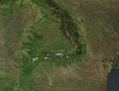
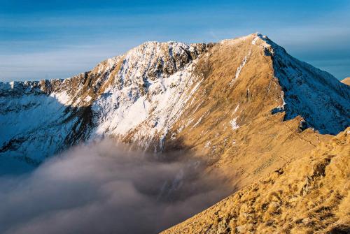
Romania consists of roughly equal parts of mountain land, high plains and low plains. Despite Romania's mountainous character, the average height is only 350 meters. The highest point in Romania is the Moldoveanu in the Fagaras Mountains (Muntii Fagarasului) in the Transylvanian Alps, at 2,548 meters. In the west lies the Bihor Mountains with the highest peak the Curcubata, 1848 meters.
The Carpathians are not as high as the Alps, but date from roughly the same geological era. The Carpathians are often divided into the Eastern Carpathians (Carpatii Orientali), the Southern Carpathians (Carpatii Meridionali) and the Western Carpathians (Carpatii Occidentali).
The Carpathian Mountains include the high plateau of Transylvania (Romanian: Transilvania). In the west of Wallachia (Romanian: Walachia or Tara Romaneasca) the Transylvanian Alps or Southern Carpathians merge into the plain of Oltenia (Romanian: Oltenia).
 Moldoveanu, Romania's highest mountainPhoto: Amorphisman, CC BY-SA 3.0 no changes made
The eastern part of the Wallachian plain is occupied by the cultivated Baragansteppe. In Moldova, the central part of the Eastern Carpathians turns into the Bîrlad plateau. North of this plateau lies the undulating plain of Iasi, south of it the plain of Focsani, which in turn joins the Danube plain with the plateau of Dobruja (Romanian: Dobrogea), a relatively high, hilly coastal region consisting of an ancient eroded rock mass. In the wooded Eastern Carpathians there are some volcanic mountain areas, such as the Muntii Calimani and the Muntii Harghitei.
Romania has different types of soils. Podzol soils predominate in the mountains, peat soils on the high plains and brown forest soils in the various lowlands of Transylvania. In the plains, the chestnut-brown soils and black soil that are characteristic of Eastern Europe developed.
Romania is a country with many dripstone caves and other karst phenomena.
Rivers and lakes
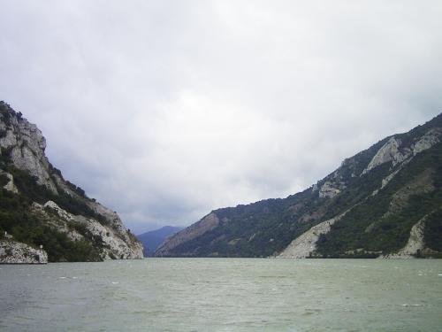
 Danube, Iron Gate, RomaniaPhoto: Denis Barthel CC 3.0 Unported no changes made
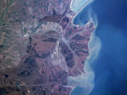
The water balance in Romania is strongly determined by the Carpathians and the Danube (Romanian: Dunarea), whose catchment area covers the whole of Romania. The Danube enters the country at Bazias and flows initially as a fast-flowing mountain river in a 150-meter wide gorge - the Iron Gates or Portile de Fier - between the Banater Mountains and the Balkan Mountains. In Wallachia, the river bed widens and the flow speed decreases sharply. The Danube delta (approx. 5050 km2), the largest delta area in Europe, lies almost entirely on Romanian territory (the rest is in Ukraine) and flows over 1075 km into Romanian territory.
The other rivers in Romania can be divided into three groups, according to origin and direction of drainage. They have in common that they all eventually find their way to the Danube.
The first group rises on the western slopes of the Carpathians and flows to the Tisa (Theiss) or the Serbian part of the Danube. One of them is Mures, whose length in Romania is 716 kilometers and flows from east to west.
The second group are the rivers (including Jiu, Arges, Dîmbovita and Ialomita) that originate in the Southern Carpathians and flow through Wallachia in a south-easterly to easterly direction to the Danube. The Olt (670 km) has its source in the Eastern Carpathians, flows through the Transylvanian Plateau, cuts through the Southern Carpathians and then makes its way to the Danube.
The third group consists of rivers that have their source in the Eastern Carpathians and in Moldova and drain to the Danube in a south-easterly direction.
The main tributary of the Danube is the Prut, which has its source in Ukraine, is 950 km long and forms the border with Ukraine for 716 km.
 Satellite image Danube Delta, RomaniaPhoto: Public domain
The approx. 3000 lakes are mainly found in the Danube Valley, the Danube Delta, high in the Carpathians and the coastal plain of Dobrogea.
The largest lakes are in fact lagoons just behind the coastline: Lacul Razelm (394 km2), Lacul Sinoe (166 km2) and Lacul Golovita (119 km2).
Another common group of lakes is that of the limans (drowned river valleys), which occur both on the coast and along the Danube in Wallachia and are over 30 km2 in size. Large reservoirs are Lacul Vidraru and Lacul Bicaz.
Sources
Bos, J.W. / Roemenië : mensen, politiek, economie, cultuur, milieu
Koninklijk Instituut voor de Tropen
Democratisering aan de Donau : Roemenië na de revolutie van 1989
Instituut voor Publiek en Politiek
Roemenië
Steunpunt Oost-Europa Projecten
Versteegen, J. / Roemenië
Gottmer
Williams, N. / Romania & Moldova
Lonely Planet
CIA - World Factbook
BBC - Country Profiles
Copyright: Team The World of Info